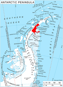
에반스 빙하 (그레이엄 랜드)
Evans Glacier (Graham Land)에반스 빙하(Evans Glacier)65°5′S 61°40′W / 65.083°S 61.667°W/ 667좌표: 65°5′S 61°40′W / 65.083°S 61.667°W) is a gently-sloping glacier 15 nautical miles (28 km) long and 4 nautical miles (7 km) wide, draining the southeast slopes of Travnik Buttress eastwards between Rugate Ridge and Poibrene Heights to flow into Vaughan Inlet on the east coast of Graham Land, Antarctica.1928년 12월 20일 휴버트 윌킨스 경에 의해 공중 비행에서 발견되었고, 그에 의해 E.S.를 위해 "Evans Input"이라고 명명되었다. 디트로이트의 에반스.1955년 포클랜드 제도 종속성 조사에 의한 추가 조사는 이 저지대가 유입구가 아니라, 현재 기술된 헬렉시아 빙하의 하류 지역에 의해 형성된다는 것을 보고했다.[1]
추가 읽기
- 1992년 국방지도국, 남극 항해 방향(계획 가이드) 및 (진행 경로) P 276
- 볼프강 랙, 남극반도 북라센 빙붕의 동적 거동 및 해체, 인스브룩, 2000년 10월
- 제인 G. 페리그노, 앨리슨 J. 쿡, 에이미 M. 마티, 리처드 S.윌리엄스 주니어, 찰스 스위틴뱅크, 케빈 M.폴리, 애드리안 J. 폭스, 자넷 W.톰슨, 욘 시버스, 남극 라르센 빙붕 지역의 해안 변화 및 빙하학 지도: 1940–2005, 미국 지질 조사 시리즈 지도 I–2600–B, 1 지도 시트, 28-p. 텍스트.
- 에티엔 베스티에, 테드 A. 스캄보스, 크리스토퍼 A.슈만, 라르센 B 지류 빙하(북극반도)의 대량 손실 2002년 이후 완화되지 않은 지구물리학 연구서, VOL. 39, L13501, doi:10.1029/2012GL051755, 2012년
외부 링크
참조
- ^ "Evans Glacier". Geographic Names Information System. United States Geological Survey. Retrieved 2012-03-06.
![]() 이 문서에는 미국 지질조사국(Geographic Names Information System)의 공용 도메인 자료가 통합되어 있다.
이 문서에는 미국 지질조사국(Geographic Names Information System)의 공용 도메인 자료가 통합되어 있다.


