체임벌린 빙하
Chamberlin Glacier이 기사는 남극의 빙하에 관한 것이다.그린란드의 빙하는 체임벌린 빙하(그린랜드)를 참조한다.
| 체임벌린 빙하 | |
|---|---|
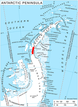
 남극 반도의 헤미몬트 고원의 위치 | |
남극의 체임벌린 빙하 위치 | |
| 위치 | 그레이엄 랜드 |
| 좌표 | 67°34′00″S 65°33′00″w/67.56667°S 65.55000°W/ -67.56667; -65.55000 |
| 두께 | 알 수 없는 |
| 최고 고도 | 549m(1,801ft) |
| 터미네이터스 | 회오리 입구 |
| 상태 | 알 수 없는 |
Chamberlin Glacier (67°34′S 65°33′W / 67.567°S 65.550°W / -67.567; -65.550Coordinates: 67°34′S 65°33′W / 67.567°S 65.550°W / -67.567; -65.550) is a glacier on the east side of Hemimont Plateau which flows northeast into Whirlwind Inlet about 4 nautical miles (7 km) southeast of Matthes Glacier, on the east coast of Graham Land.
역사
체임벌린 빙하는 1928년 12월 20일 비행기에서 휴버트 윌킨스 경에 의해 발견되었고, 1940년 미국 남극 서비스에 의해 공중에서 촬영되었다.그것은 1947년 미국 빙하학자 및 지질학자 토마스 C를 위해 이름을 붙인 포클랜드 제도 의존성 조사에 의해 도표로 작성되었다. 체임벌린, 위스콘신 및 시카고 대학의 지질학 교육자 겸 교수.[1]
참고 항목
참조
- ^ "Chamberlin Glacier". Geographic Names Information System. United States Geological Survey. Retrieved 1 November 2011.
![]() 이 문서에는 미국 지질조사국(Geographic Names Information System)의 공용 도메인 자료가 통합되어 있다.
이 문서에는 미국 지질조사국(Geographic Names Information System)의 공용 도메인 자료가 통합되어 있다.
이 Bowman Coast 로케이션 기사는 단조롭다.위키피디아를 확장하여 도울 수 있다. |


