Template:Infobox body of water/testcases

Side by side comparison
{{Infobox body of water}}{{Infobox body of water/sandbox}}
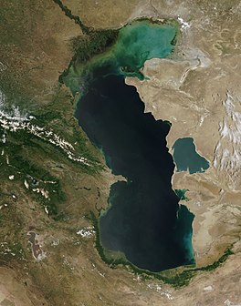
Caspian Sea
Foorbar Sea
As captured by the MODIS on the orbiting Terra satellite
Coordinates40°N 51°E / 40°N 51°E / 40; 51
TypeEndorheic, Saline, Permanent, Natural
Primary inflowsVolga River
Primary outflowsEvaporation
Catchment area3,626,000 km2 (1,400,000 sq mi)[1]
Basin countriesAzerbaijan, Iran, Kazakhstan, Russia, Turkmenistan
Surface area371,000 km2 (143,000 sq mi)
Average depth184 m (604 ft)
Water volume78,200 km3 (18,800 cu mi)
Residence time250 years
Surface elevation−28 m (−92 ft)
Islandsnumerous (see article)
SettlementsBaku (Azerbaijan), Rasht (Iran), Aktau (Kazakhstan), Makhachkala (Russia), Türkmenbaşy (Turkmenistan) (see article)
References[1]
Side by side comparison
{{Infobox body of water}}{{Infobox body of water/sandbox}}
Green Lake
Deadman's Point; a "marl reef" is visible in the water.
LocationOnondaga County, New York
Coordinates43°03′00″N 75°57′58″W / 43.05°N 75.966°W / 43.05; -75.966
Lake typemeromictic
Basin countriesUnited States
Max. length1,141 m (3,743 ft)
Max. width250 m (820 ft)
Surface area0.258 km2 (0.100 sq mi)
Average depth52 m (171 ft)
Water volume7,235,900 m3 (5,866.2 acre⋅ft)
Shore length12,840 m (9,320 ft)
1 Shore length is not a well-defined measure.
Side by side comparison
{{Infobox body of water}}{{Infobox body of water/sandbox}}
Lake Lucerne
Vierwaldstättersee (German)
View from Weggis
map
LocationCentral Switzerland
Coordinates47°01′10″N 8°24′04″E / 47.01944°N 8.40111°E / 47.01944; 8.40111
Primary inflowsReuss River
Sarner Aa
Engelberger Aa
Muota
Primary outflowsReuss River
Catchment area2,124 km2 (820 sq mi)
Basin countriesSwitzerland
Surface area113.6 km2 (43.9 sq mi)
Average depth104 m (341 ft)
Max. depth214 m (702 ft)
Water volume11.8 km3 (9,600,000 acre⋅ft)
Residence time3.4 years
Shore length1143.7 km (89.3 mi)
Surface elevation433 m (1,421 ft)
IslandsAltstad-Insel (islet)
Sections/sub-basinsLake Uri, Treib basin, Gersau Basin, Weggis/Vitznau Basin, Lake Küssnacht, Kreuztrichter basin, Lake Alpnach, Lucerne Bay
SettlementsLucerne (see article)
1 Shore length is not a well-defined measure.
Side by side comparison
{{Infobox body of water}}{{Infobox body of water/sandbox}}
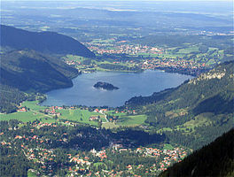
Schliersee
As seen from Mount Jägerkamp
LocationUpper Bavaria
Coordinates47°43′19″N 11°51′45″E / 47.72194°N 11.86250°E / 47.72194; 11.86250
Basin countriesGermany
Max. length2.3 km (1.4 mi)
Max. width1.3 km (0.81 mi)
Surface area2.241 km2 (0.865 sq mi)
Max. depth40 m (130 ft)
Surface elevation777 m (2,549 ft)
Islands1 (Wörth island)
SettlementsSchliersee
Side by side comparison
{{Infobox body of water}}{{Infobox body of water/sandbox}}
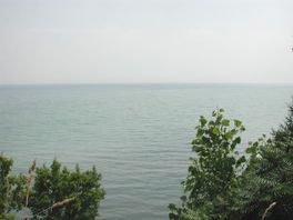
Lake Erie
From a high bluff near Leamington, Ontario
LocationGreat Lakes
Coordinates42°12′N 81°12′W / 42.2°N 81.2°W / 42.2; -81.2
Primary inflowsDetroit River
Primary outflowsNiagara River
Basin countriesCanada, United States
Max. length241 mi (388 km)
Max. width57 mi (92 km)
Surface area9,940 sq mi (25,744 km2)[2]
Average depth62 ft (19 m)
Max. depth210 ft (64 m)[2]
Water volume116 cu mi (480 km3)
Residence time2.6 years
Shore length1850 mi (1,370 km)
Surface elevation571 ft (174 m)[2]
Islands24+ (see list)
SettlementsBuffalo, New York
Erie, Pennsylvania
Toledo, Ohio
Monroe, Michigan
Cleveland, Ohio
References[2]
1 Shore length is not a well-defined measure.
Side by side comparison
{{Infobox body of water}}{{Infobox body of water/sandbox}}
Lenore Lake
LocationGrant County, Washington
Basin countriesUnited States
Max. length8 mi (13 km)
Lenore Lake
LocationGrant County, Washington
Basin countriesUnited States
Max. length8 mi (13 km)
Side by side comparison
{{Infobox body of water}}{{Infobox body of water/sandbox}}
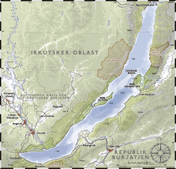
Lake Baikal
Shaman-Stone of the Olkhon Island
Coordinates53°30′N 108°12′E / 53.5°N 108.2°E / 53.5; 108.2
TypeContinental rift lake
Primary inflowsSelenga, Chikoy, Khilok, Uda, Barguzin, Upper Angara
Primary outflowsAngara
Catchment area560,000 km2 (220,000 sq mi)
Basin countriesRussia
Max. length636 km (395 mi)
Max. width79 km (49 mi)
Surface area31,494 km2 (12,160 sq mi)
Average depth758 m (2,487 ft)
Max. depth1,637.1 m (5,371 ft)
Water volume23,600 km3 (1.91×10¹⁰ acre⋅ft)
Residence time350 years
Shore length12,100 km (1,300 mi)
Surface elevation456 m (1,496 ft)
FrozenJanuary–May
Islands22 (Olkhon)
SettlementsIrkutsk
1 Shore length is not a well-defined measure.
Side by side comparison
{{Infobox body of water}}{{Infobox body of water/sandbox}}
Champagne Pool
The orange colour originates from deposits of arsenic and antimony sulfides.
Champagne Pool is located in New Zealand
Champagne Pool
Champagne Pool
Location in New Zealand
Champagne Pool is located in Oceania
Champagne Pool
Champagne Pool
Location in Oceania
Location Waiotapu, North Island
Coordinates38°22′S 176°21′E / 38.37°S 176.35°E / -38.37; 176.35
Typegeothermal
Basin countriesNew Zealand
Max. length65 km (40 mi)
Max. depth62 m (203 ft)
Water volume50,000 m3 (41 acre⋅ft)
Residence time34 days
Champagne Pool
The orange colour originates from deposits of arsenic and antimony sulfides.
Champagne Pool is located in New Zealand
Champagne Pool
Champagne Pool
Location in New Zealand
Champagne Pool is located in Oceania
Champagne Pool
Champagne Pool
Location in Oceania
Location Waiotapu, North Island
Coordinates38°22′S 176°21′E / 38.37°S 176.35°E / -38.37; 176.35
Typegeothermal
Basin countriesNew Zealand
Max. length65 km (40 mi)
Max. depth62 m (203 ft)
Water volume50,000 m3 (41 acre⋅ft)
Residence time34 days

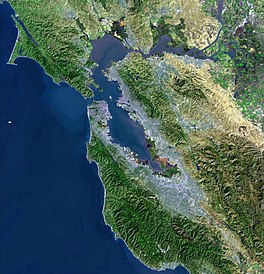
San Francisco Bay

edit
Side by side comparison
{{Infobox body of water}}{{Infobox body of water/sandbox}}
San Francisco Bay
Spanish: Bahía de San Francisco
Coordinates37°39′17″N 122°14′15″W / 37.6546543°N 122.2374676°W / 37.6546543; -122.2374676[3]
TypeBay
River sourcesSacramento River
San Joaquin River
Petaluma River
Napa River
Guadalupe River
Ocean/sea sourcesPacific Ocean
Basin countriesUnited States
Max. length97 km (60 mi)
Max. width19 km (12 mi)
Surface area400–1,600 sq mi (1,000–4,100 km2)
SettlementsSan Jose
San Francisco
Oakland
Official nameSan Francisco Bay/Estuary (SFBE)
DesignatedFebruary 2, 2013
Reference no.2097[4]

Lake Ladoga

edit

Test mapframe with mapframe-length_km set

Side by side comparison
{{Infobox body of water}}{{Infobox body of water/sandbox}}
Lake Ladoga
LocationNorthwestern Russia (Leningrad Oblast and the Republic of Karelia)
Coordinates61°00′N 31°30′E / 61.000°N 31.500°E / 61.000; 31.500
Primary inflowsSvir, Volkhov, Vuoksi
Primary outflowsNeva
Catchment area276,000 km2 (107,000 sq mi)
Basin countriesRussia
Finland (minor)
Max. length219 km (136 mi)
Max. width138 km (86 mi)
Surface area17,891 km2 (6,908 sq mi)
Average depth47.3 m (155 ft)
Max. depth230–260 m (750–850 ft)
Water volume837 km3 (201 cu mi)
Surface elevation5 m (16 ft)
Islandsabout 660 (including Valaam)
Settlementssee list
Map

All lake parameters

edit
Side by side comparison
{{Infobox body of water}}{{Infobox body of water/sandbox}}
{{{name}}}
{{{other_name}}}
an example image
{{{caption}}}
an example image
{{{caption_bathymetry}}}
Location{{{location}}}
Group{{{group}}}
Coordinates{{{coords}}}
Type{{{type}}}
Primary inflows{{{inflow}}}
Primary outflows{{{outflow}}}
Catchment area{{{catchment}}}
Basin countries{{{basin_countries}}}
Managing agency{{{agency}}}
Designation{{{designation}}}
Built{{{date-built}}}
First flooded{{{date-flooded}}}
Max. length{{{length}}}
Max. width{{{width}}}
Surface area{{{area}}}
Average depth{{{depth}}}
Max. depth{{{max-depth}}}
Water volume{{{volume}}}
Residence time{{{residence_time}}}
Shore length1{{{shore}}}
Surface elevation{{{elevation}}}
Frozen{{{frozen}}}
Islands{{{islands}}}
Sections/sub-basins{{{sections}}}
Settlements{{{cities}}}
Website{{{website}}}
References{{{reference}}}
1 Shore length is not a well-defined measure.

References

  1. ^ a b van der Leeden, Troise, and Todd, eds., The Water Encyclopedia. Second Edition. Chelsea, MI: Lewis Publishers, 1990, page 196.
  2. ^ a b c d Wright, John W. (ed.); Editors and reporters of The New York Times (2006). The New York Times Almanac (2007 ed.). New York, New York: Penguin Books. p. 64. ISBN 0-14-303820-6. {{cite book}}: |first= has generic name (help)
  3. ^ "San Francisco Bay". Geographic Names Information System. United States Geological Survey, United States Department of the Interior. January 19, 1981. Retrieved January 2, 2017.
  4. ^ "San Francisco Bay/Estuary (SFBE)". Ramsar Sites Information Service. Retrieved April 25, 2018.