므윌레아
Mweelrea| 므윌레아 | |
|---|---|
| 첸코 마올 리드; 매끄러운 대머리 언덕 | |
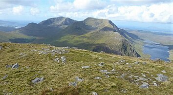
 동쪽의 벤 러그모어에서 바라본 므엘레아와 로프 벨라와움의 코리호 | |
| 최고점 | |
| 표고 | 814m(2,671ft)[1] |
| 두각을 나타남 | 779m(2,556ft)[1] |
| 목록 | 카운티 탑(Mayo), P600, 100개의 가장 높은 아일랜드 산맥, 마릴린, 휴이트, 아르데린, 심엠, 반델리에르-리남 |
| 좌표 | 53°38′14″N 9°49′49″w / 53.63724°N 9.830358°W좌표: 53°38′14″N 9°49′49″W / 53.63724°N 9.830358°W/ |
| 이름 지정 | |
| 영어 번역 | 반들반들한 대머리 언덕 |
| 이름 언어 | 아일랜드어 |
| 발음 | /mwiːlˈreɪ/ |
| 지리 | |
| 위치 | 아일랜드 메이요 주 |
| 상위 범위 | 므윌레아 산맥 |
| OSI/OSNI 그리드 | L7898366810 |
| 토포 지도 | OSi Discovery 37 |
| 지질학 | |
| 산형 | 사암 & 대기업, 이그넴브라이트 기반암[1] |
| 등반 | |
| 가장 쉬운 경로 | "실버 스트랜드"[2] |
| 정상로 | "더 램프"(Lug More corrie)[3] |
Mweelrea (/mwiːlˈreɪ/; 아일랜드의 Cnoc Maol Réidh의 '매끄러운 꼭대기가 있는 발드 힐')[4]은 814m(2,671ft)로, 아일랜드에서 26번째로 높은 봉우리로,[5] 반델린-리남 눈금에서는 34번째로 높은 봉우리다.[6][7] Mweelrea는 Ben Lugmore와 Ben Burge의 봉우리들을 포함하는 "호르스회 모양의" 마사회의 꼭대기 근처에 위치해 있으며, 아일랜드 메이요에 있는 킬라리 하버와 두루 사이에 위치해 있다.[7][8] Mweelrea는 코나흐트의 지방 최고봉으로 남동쪽 절벽에 줄지어 있는 산호초와 [8][9]전망으로 유명하다.[10] 마시프는 므윌레아 산맥 또는 므윌레아 산맥이라고 불린다.[3][9]
이름 지정
Mweelrea는 아일랜드어: Cnoc Maol Réidh의 성공회화로서, "상단이 매끄러운 언덕"으로 번역되며, 산의 모습을 묘사한다.[4]
지질학
Mweelrea Formation이라고 알려진 것의 지질학은 킬라리 하버의 반대편에 있는 12번가의 지질학과는 매우 다르다. 요약 수준에서, Mweelrea Formation은 원래 큰 충적 팬에 침전된 오르도비안 시대 사암과 편평한 충적 평원과 델타 팬으로 구성된다. 이 사암들과 섞여 있는 것은 투프트인데, 오르도비안 시대 화산의 화산재 퇴적물이다.[11][12]
지리
Mweelrea와 그 부속 봉우리들은 아일랜드의 가장 깊은 피오르드인 킬라리 하버와 북쪽으로는 두 로우가 경계를 이루는 Mweelrea 산맥의 "호르스회 모양의" 마사지프 남반부를 형성한다.[8][9]
이 '호르세스회'의 중심에 있는 계곡은 글렌콘넬리(이리쉬: Glean Choinnile)의 타운랜드다.[13] Two deep corries lie at the head of the Glenconnelly valley, below Mweelrea's southeast face; the southerly corrie contains Lough Lugaloughan, while the northerly corrie contains Lough Bellawaum; both are drained by the Sruhaunbunatrench River, which empties into the Bundorragha River, which itself flows into Killary Harbour.[9]
Mweelrea는 814미터(2,671피트)로 마시프에서 가장 높은 산이며, 코나흐트의 지방 정상이다.[8][9] 음웰레아가 779m(2,556ft)로 두각을 나타낸 것은 마릴린에 해당하며, 최소 두각기준이 100m인 마운틴뷰즈 온라인 데이터베이스(MountainViews Online Database)에서 아일랜드에서 16번째로 높은 산으로 평가되기도 한다.[7][14]
Northeast of Mweelrea is Ben Bury (or Irish: Ucht an Chreagáin, meaning "breast of the little crag"; it is also known as "Oughty Craggy"), at 795 metres (2,608 ft), and whose prominence of 60 metres (200 ft) qualifies it as a Vandeleur-Lynam (it is the 43rd-highest Vandeleur-Lynam in Ireland).[7][9]
"호르스회" 주변 동쪽에는 803미터(2,635피트)의 Mweelrea보다 약간 낮은 벤 러그모어(및 그 자회사의 봉우리)의 긴 정상 능선이 있고, 북동쪽 얼굴은 절벽으로 줄지어 있는 러그 모어 아일랜드인 쿰 더브 코리(Com Dubh corrie)의 머리벽을 이루고 있다.[8][9]
므윌레아의 남서쪽은 '호르스회'의 남쪽 팔로 북쪽보다 낮으면서도 지지도가 낮다. It includes the Mweelrea SE Spur at 495 metres (1,624 ft) (sometimes called "point-495" in guidebooks), and finishes with the isolated Teevnabinnia (Irish: Taobh na Binne, meaning "side of the peak"), whose height is only 379 metres (1,243 ft), but whose prominence of 214 metres (702 ft) qualifies it as a Marilyn.[7][9] Mweelrea의 서쪽에는 Uggool 해변과 Silver Strand의 Mayo 카운티 해변이 있다.
레크리에이션
힐 워킹
코나흐트에서 가장 높은 산으로서, 므엘레아는 아일랜드의 4개 성에서 가장 높은 산으로 "4봉우리 도전" 형식으로 올라간다.[15]
Mweelrea 정상으로 가는 가장 빠르고 간단한 방법은 8킬로미터의 실버 스트랜드 경로를 경유하는 것이다.[2]
더 긴 노선은 루그 모어(또는 아일랜드어: Cum Dubh) 코리호와 그린 글렌 글렌쿨린의 계곡을 경유하는 왕복 13km의 6시간 거리. 벤 베리와 벤 러그모어의 정상에 오르는 길이다. 더 램프로 알려진 주목할 만한 특징이 사용되는데, 그것은 중도에 있는 이 코리어의 헤드월을 가로질러, 동쪽에서 서쪽으로 상승 경사로를 가로지르고, 벤 베리와 함께 있는 콜에서 벤 러그모어의 산등성이에 도달한다. 이 경로는 직선적이지만, 코리에는 넓은 절벽이 있기 때문에 더 램프를 제대로 찾는데 주의를 기울여야 한다.[3]
Mweelrea는 또한 유명한 아일랜드 가이드북에 의해 아일랜드의 "톱 3" 중 하나로 묘사되는 15 킬로 미터 6-7시간 Mweelrea Horshoe의 일부로 올라간다.[8] 회로는 델파이 마운틴 리조트에서 시작하고 끝나며, 벤 러그모어(및 그 부속 봉우리), 벤 베리, 므윌레아, 므윌레아 SE 스퍼(또는 지점 495미터) 등 므윌레아의 모든 마시프의 봉우리를 취입한다.[8][9]
암벽등반
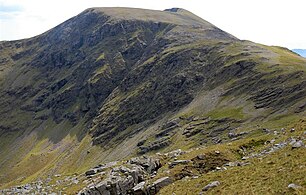
므엘레아 마시프의 주요 암벽은 벤 러그모어의 북동쪽 경사면(여기 참조)[16]에 있는 반면, 므엘레아/벤 베리의 북동쪽 경사면에는 긴 1,2급 스크램블이 있다.
겨울 등산
므엘레아의 북동쪽 산호인 러프 벨라와움 코리에도 많은 겨울 산호들이 있는데, 그중에서도 가장 눈에 띄는 것은 블루 루트(등급 II/III, 270m), 레드 루트(등급 III, 305m)이다.[17]
갤러리
벤 러그모어에서 바라본 므엘레아와 로프 벨라와움의 코리호
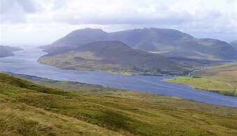
리나운 힐에서 본 Mweelrea massif, Mweelrea(왼쪽 뒤), Ben Lugmore(뒤, 오른쪽), Teevnabinnia(중앙, 앞)가 있다.
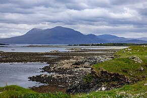
렌바일의 남쪽에서 바라본 음웨레아
참고 문헌 목록
- Fairbairn, Helen (2014). Ireland's Best Walks: A Walking Guide. Collins Press. ISBN 978-1848892118.
- MountainViews Online Database (Simon Stewart) (2013). A Guide to Ireland's Mountain Summits: The Vandeleur-Lynams & the Arderins. Collins Books. ISBN 978-1-84889-164-7.
- Paul Phelan (2011). Connemara & Mayo - A Walking Guide: Mountain, Coastal & Island Walks. Collins Press. ISBN 978-1848891029.</ref>
- Dillion, Paddy (2001). Connemara: Collins Rambler's guide. Harper Collins. ISBN 978-0002201216.
- Dillion, Paddy (1993). The Mountains of Ireland: A Guide to Walking the Summits. Cicerone. ISBN 978-1852841102.
참고 항목
| 위키미디어 커먼즈에는 므윌레아 산맥과 관련된 미디어가 있다. |
- 코네마라에서 주요 사정거리인 맘투르크
- 코네마라 주요 레인지인 12벤스
- 아일랜드 카운티 목록
- 아일랜드의 산 목록
- 영국 제도의 산과 언덕 목록
- 영국 섬의 P600 산 목록
- 영국의 마릴린스 섬 목록
- 잉글랜드, 웨일스, 아일랜드의 휴이트 산 목록
참조
- ^ a b c "Mweelrea". MountainViews Online Database. Retrieved 16 August 2019.
- ^ a b "Mweelrea: Silver Strand Route (Start at L76288 68802)". Mountainview.ie.
This is the easiest and quickest way to get to te top of Mweelrea, but it's mostly just a bog walk. I did it in just under 3 hours. You can park where the track leaves the road, or add in the road walk and park at the beach at the end of the road. The track to open land is marked with a cul de sac sign and there are no fences once you get through the gate. Care should be taken on the upper section of the walk and should not be attempted in high winds or when the cloud base comes in due to cliffs near the summit.
- ^ a b c Paul Phelan (2011). Connemara & Mayo - A Walking Guide: Mountain, Coastal & Island Walks. Collins Press. ISBN 978-1848891029.
Walk 27: Mweelrea
- ^ a b Paul Tempan (February 2012). "Irish Hill and Mountain Names" (PDF). MountainViews.ie.
- ^ Simon Stewart (October 2018). "Arderins: Irish mountains of 500+m with a prominence of 30m". MountainViews Online Database.
- ^ Simon Stewart (October 2018). "Vandeleur-Lynams: Irish mountains of 600+m with a prominence of 15m". MountainViews Online Database.
- ^ a b c d e 마운틴뷰(2013년 9월), "아일랜드 마운틴 서밋 가이드: 반델레우르-리남스 & 아르데린스' 콜린스 북스, 코르크, ISBN 978-1-84889-164-7
- ^ a b c d e f g Fairbairn, Helen (2014). Ireland's Best Walks: A Walking Guide. Collins Press. ISBN 978-1848892118.
Route 29: Mweelrea
- ^ a b c d e f g h i Dillion, Paddy (1993). The Mountains of Ireland: A Guide to Walking the Summits. Cicerone. ISBN 978-1852841102.
"Walk 53: Mweelrea, Ben Bury, Ben Lugmore
- ^ Michael Guilfoyle (6 April 2016). "A Walk for the Weekend: the magic of Mweelrea". Irish Times.
My favourite mountain in the world is Mweelrea. From its summit, 16 years ago, I watched the last light of the millennium sink into a hushed Atlantic.
- ^ David M. Williams (April 1984). "The stratigraphy and sedimentology of the Ordovician Partry Group, southeastern Murrisk, Ireland". Geological Journal. 9 (2): 173–186. doi:10.1002/gj.3350190206.
- ^ David M. Williams (1984). The geology around Killary harbour, Co. Galway : Field Series No. 3 (PDF). The Irish Geological Association.
- ^ "Gleann Choinnile: Glenconnelly". Irish Placenames Database. Retrieved 19 August 2019.
- ^ "Irish Highest 100: The highest 100 Irish mountains with a prominence of +100m". MountainViews Online Database. September 2018.
- ^ "Interview: Nikki Bradley on her Upcoming Four Peaks Challenge". Outsider Magazine. 9 July 2018.
- ^ "Mweelrea/Ben Bury Scrambles". Irish Climbing Wiki. Retrieved 20 August 2019.
- ^ "Winter climbing Connemara/South Mayo group". Irish Climbing Wiki. Retrieved 18 August 2019.
외부 링크
- 마운틴뷰즈: 아일랜드 마운틴 웹사이트, Mweelrea
- 마운틴뷰: 아일랜드 온라인 마운틴 데이터베이스
- 영국식 섬 산의 가장 큰 데이터베이스인 영국과 아일랜드식 언덕 데이터베이스("DoBIH")
- Hill Bagging UK & Areland, DoB의 검색 가능한 인터페이스IH

