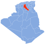
Djelfa 구
Djelfa DistrictDjelfa 구 | |
|---|---|
 | |
| Coordinates:좌표: 34°47′17.9″N 3°13′43.9″E / 34.788306°N 3.228861°E | |
| 나라 | |
| 주 | 젤파 주 |
| 자본의 | 젤파 |
| 시간대 | UTC+1(CET) |
젤파 구 는 젤파 지방에 있는 알제리 행정구역이다.수도는 젤파 마을이다.[1][2]
코뮌
그 지역은 오직 하나의 공동체로 구성되어 있다.젤파.
참조
- ^ "Djelfa District". OpenStreetMap. OpenStreetMap. Retrieved 6 May 2018.
- ^ Amri, Kamel; et el (16 February 2017). "Mapping geology in Djelfa District (Saharan Atlas, Algeria), using Landsat 7 ETM+ data: an alternative method to discern lithology and structural elements". Arabian Journal of Geosciences. Current Advances in Geology of North Africa (4). doi:10.1007/s12517-017-2883-6.


