코모도로
Comodoro코모도로 시 | |
|---|---|
시 | |
 | |
| 닉네임: "신서방" | |
 코모도로의 위치 | |
| 나라 | |
| 지역 | 중서부 |
| 주 | 마토 그로소 |
| 메소레지온 | 노르트마토크로센스 |
| 설립됨 | 1986 |
| 면적 | |
| • 합계 | 8,407.07 sq mi(21,774.22km2) |
| 표고 | 2,000피트(600m) |
| 인구 (2020 [1]) | |
| • 합계 | 21,008 |
| • 밀도 | 2.1/sq mi(0.82/km2) |
| 데모닉 | 코모도렌세 |
| 시간대 | UTC-3(BRT) |
| 우편 번호(CEP) | 78310-000 |
| 지역 번호 | +55 65 |
| 웹사이트 | 코모도로, 마토 그로소 |
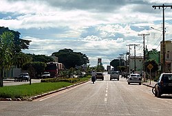
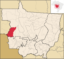
코모도로(Comodoro)는 브라질 중서부 마토 그로소 주에 있는 시이다.[2][3][4][5]
참고 항목
참조
- ^ IBGE 2020
- ^ "Divisão Territorial do Brasil" (in Portuguese). Divisão Territorial do Brasil e Limites Territoriais, Instituto Brasileiro de Geografia e Estatística (IBGE). July 1, 2008. Retrieved December 17, 2009.
- ^ "Estimativas da população para 1º de julho de 2009" (PDF) (in Portuguese). Estimativas de População, Instituto Brasileiro de Geografia e Estatística (IBGE). August 14, 2009. Archived from the original (PDF) on June 26, 2013. Retrieved December 17, 2009.
- ^ "Ranking decrescente do IDH-M dos municípios do Brasil" (in Portuguese). Atlas do Desenvolvimento Humano, Programa das Nações Unidas para o Desenvolvimento (PNUD). 2000. Archived from the original on October 3, 2009. Retrieved December 17, 2009.
- ^ "Produto Interno Bruto dos Municípios 2002-2005" (PDF) (in Portuguese). Instituto Brasileiro de Geografia e Estatística (IBGE). December 19, 2007. Archived from the original (PDF) on October 2, 2008. Retrieved December 17, 2009.


