아스프레몬트, 하우테스-알페스
Aspremont, Hautes-Alpes아스프레몬트 | |
|---|---|
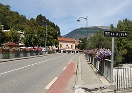
 Aspremont의 Buech 강을 가로지르는 고속도로 다리(구 N75) | |
| 좌표:44°29~36°N 5°43°42°E/44.4933°N 5.7283°E좌표: 44°29°36°N 5°43°42°E / 44.4933°N 5.7283°E / | |
| 나라 | 프랑스. |
| 지역 | 프로방스알프 코트다쥐르 |
| 부서 | 오테알페스 |
| 아롱디스망 | 갭 |
| 칸톤 | 세라 |
| 인터커뮤니티 | 부에흐 데볼루이 |
| 정부 | |
| • 시장(2020–2026) | 자크[1] 프랑쿠 |
| 지역 1 | 18.52km2(7.15평방마일) |
| 인구. (2019년 [2]1월) | 369 |
| • 밀도 | 20/km2(52/150mi) |
| 시간대 | UTC+01:00 (CET) |
| • 여름 (DST) | UTC+02:00 (CEST) |
| INSEE/우편번호 | 05008/05140 |
| 승진 | 696~1,378m (2,283~4,521피트) (평균 715m 또는 2,346ft) |
| 1 프랑스2 토지 등록부 데이터는 호수, 연못, 빙하 > 1km(0.386 평방 미 또는 247 에이커)와 강 하구를 제외한다. | |
아스프레몽(프랑스어 발음: aspəmm̃̃)은 프랑스 남동부 오트알페주에 있는 코뮤니티이다.
인구.
| 연도 | Pop. | ±% |
|---|---|---|
| 2006 | 294 | — |
| 2007 | 303 | +3.1% |
| 2008 | 306 | +1.0% |
| 2009 | 315 | +2.9% |
| 2010 | 320 | +1.6% |
| 2011 | 324 | +1.2% |
| 2012 | 327 | +0.9% |
| 2013 | 326 | −0.3% |
| 2014 | 332 | +1.8% |
| 2015 | 341 | +2.7% |
| 2016 | 350 | +2.6% |
「 」를 참조해 주세요.
레퍼런스
- ^ "Répertoire national des élus: les maires". data.gouv.fr, Plateforme ouverte des données publiques françaises (in French). 2 December 2020.
- ^ "Populations légales 2019". The National Institute of Statistics and Economic Studies. 29 December 2021.
Wikimedia Commons에는 Aspremont(Hautes-Alpes) 관련 미디어가 있습니다.


