아서 패스
Arthur Passage| 아서 패스 | |
|---|---|
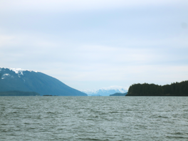
 남쪽 아서 패시지를 내려다보다 | |
| 좌표 | 54°01′45§ N 130°14′21″w/54.02917°N 130.23917°W좌표: 54°01°45°N 130°14°21°W / 54.02917°N 130.23917°W / |
Arthur Passage는 캐나다 브리티시컬럼비아에 있는 해양 수로이다.그렌빌 해협(동남쪽 끝)과 말라카 해협(서북쪽 끝)[1]을 연결하는 내부 통로의 일부입니다.이 통로의 [2]북단 중앙에 위치한 한머섬이 눈에 띈다.
이름 유래
Arthur Passage는 1867년 선장 Daniel Pender에 의해 밴쿠버 섬의 세 번째 주지사 Arthur E.[3] Kennedy의 이름을 따서 명명되었다.
생태학
Arthur Passage를 둘러싸고 있는 초산림에는 습기가 많고 성장이 느린 서부 레드세다르 숲과 노랑세다르 숲이 광범위하게 분포되어 있습니다.한머섬 숲속 마크로파우나에는 소똥벌레, 밀리페데스, 지네즈, 화분벌레, [4]지렁이 등이 있다.
수문학
아서 패스의 조수는 북쪽으로 흐르고 남쪽으로 썰물은 [1]해머섬 부근에서 2.5노트(4.6km/h; 2.9mph)에 이른다.
역사
1942년 1월 14일 아침, 350명의 승객을 태운 미 해군 항공모함 데이비드 W. 지부가 해머 [5]섬에서 좌초했다.
「 」를 참조해 주세요.
레퍼런스
- ^ a b "Charts 3927, 3773, 3717, Arthur Passage". Sailing Directions, British Columbia Coast, (Northern Portion). II (Ninth Edition): 162–163. 1983.
- ^ "Hanmer Island". BC Geographical Names.
- ^ "Arthur Passage". BC Geographical Names.
- ^ J.M. Kranabetter and A. BannerA. Selected biological and chemical properties offorest floors across bedrock types on the northcoast of British Columbia (Report). pp. 971–981.
{{cite report}}: CS1 maint: 작성자 파라미터 사용(링크) Kranabetter, J.M.; Banner, A. (February 2011). "Selected biological and chemical properties offorest floors across bedrock types on the northcoast of British Columbia". Canadian Journal of Forest Research. 30 (6): 971–981. doi:10.1139/x00-018. Retrieved 2020-03-20. - ^ Roy, Dr. R. H. (1976). "[PDF] The Defence of Prince Rupert: An Eyewitness Account". The British Columbian Quarterly. Retrieved 2020-03-20.
외부 링크
![]() Wikimedia Commons의 Arthur Passage 관련 매체
Wikimedia Commons의 Arthur Passage 관련 매체


