Grid reference D0336
near to The Dry Arch, Co Antrim, Northern Ireland
We have
9 images
for D0336

|
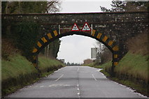
The Dry Arch near Armoy
Flyovers existed long before the first motorway or even dual carriageway. The Dry Arch (north of Armoy) was built around 1830/40. It carries the Armoy-Ballintoy road across the Ballybogey-Ballycastle road. Both are “B” roads. See also... (more)
|

|
Lisnagat Road near Armoy
by Rossographer
Minor road about 2 miles north-west of Armoy in the townland of Carrowreagh Lower.
|

|
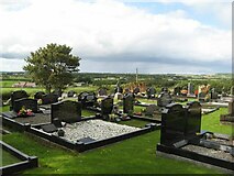
Parish church graveyard
A view from the graveyard of Drumtullagh parish Church. While many of the graves have modern memorials, some are much older and apparently hewn from a dark, igneous rock possibly gabbro of local provenance. The rustic headstones are... (more)
|

|
Road sign, Lisnagat Road
by Rossographer
Sign for the Lisnagat Road D0336 : Lisnagat Road near Armoy near Armoy.
|

|
Drumtullagh Parish Church
by Rossographer
Drumtullagh Parish (Church of Ireland) located on the Lisnagat Road near Armoy.
|

|
The Dry Arch near Armoy (1980)
See D0336 : The Dry Arch near Armoy (January 2007). An earlier view, looking towards Moss-Side and Coleraine. The arch has a height restriction of 12ft 6.
|

|
The Dry Arch near Armoy
by Rossographer
The dry arch near Armoy, looking in the direction of Coleraine. See also D0336 : The Dry Arch near Armoy (1980) from 1980 - little has changed in 43 years, although this is a fast stretch of road so extreme care was needed in taking photographs.
|

|
Flush Bracket, The Dry Arch
by Rossographer
Flush bracket bench mark on the northern abutment of the dry arch near Armoy (on the B67 Moyarget Road - on the right of D0336 : The Dry Arch near Armoy approximately 1 metre off the ground, so getting a picture is very difficult and quite dangerous - care... (more)
|

|
Drumtullagh Parish graveyard
Looking over modern memorials to fields beyond Lisnagat Road.
|
|
