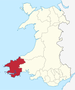
Pembrokeshire
| Pembrokeshire | ||
| Sir Benfro | ||
| Kommun, grevskap | ||
|
||
| Land | ||
|---|---|---|
| Riksdel | Wales | |
| Bevarat grevskap | Dyfed | |
| Administrativ huvudort |
Haverfordwest | |
| Yta | 1 618 km²[1] | |
| Folkmängd | 124 367 (2022)[2] | |
| Befolkningstäthet | 77 invånare/km² | |
| Tidszon | GMT (UTC+0) | |
| - sommartid | BST (UTC+1) | |
| GSS-kod | W06000009 | |
| Geonames | 2640500 | |
Pembrokeshire (kymriska: Sir Benfro) är ett grevskap och en kommun (principal area) i sydvästra Wales. Det gränsar till Carmarthenshire och Ceredigion.
Det traditionella grevskapet Pembrokeshire upprättades år 1282 av Edvard I av England. Det har länge bestått av en engelskdominerad del i söder (känd som Little England beyond Wales, "Lilla England bortom Wales") och en kymriskdominerad del i norr.
Från 1974 till 1996 var grevskapet delat i två distrikt, South Pembroke och Preseli som låg under grevskapet Dyfed. Då distrikten avskaffades som administrativa enheter år 1996 blev Pembrokeshire återupprättat, och har sedan dess blivit styrt som en kommun. 30 juni 2017 hade Pembrokeshire 125 055 invånare.[3]
Större orter i Pembrokeshire
[redigera | redigera wikitext]| Ort | Invånare [a] |
|---|---|
| Fishguard | 3 500 |
| Haverfordwest | 14 500 |
| Milford Haven | 13 500 |
| Neyland | 3 500 |
| Pembroke | 7 500 |
| Pembroke Dock | 10 000 |
| Saundersfoot | 3 500 |
| Tenby | 4 500 |
Administrativ indelning
[redigera | redigera wikitext]Pembrokeshire är indelat i 77 communities.
- Ambleston
- Amroth
- Angle
- Boncath
- Brawdy
- Burton
- Camrose
- Carew
- Cilgerran
- Clydau
- Clynderwen
- Cosheston
- Crymych
- Cwm Gwaun
- Dale
- Dinas Cross
- East Williamston
- Eglwyswrw
- Fishguard and Goodwick
- Freystrop
- Haverfordwest
- Hayscastle
- Herbrandston
- Hook
- Hundleton
- Jeffreyston
- Johnston
- Kilgetty/Begelly
- Lampeter Velfrey
- Lamphey
- Letterston
- Llanddewi Velfrey
- Llandissilio West
- Llangwm
- Llanrhian
- Llanstadwell
- Llawhaden
- Maenclochog
- Manorbier
- Manordeifi
- Marloes and St. Brides
- Martletwy
- Mathry
- Merlin's Bridge
- Milford Haven
- Mynachlog-Ddu
- Narberth
- Nevern
- New Moat
- Newport
- Neyland
- Nolton and Roch
- Pembroke
- Pembroke Dock
- Penally
- Pencaer
- Puncheston
- Rosemarket
- Rudbaxton
- Saundersfoot
- Scleddau
- Solva
- Spittal
- St Florence
- St Ishmael's
- St. David's and the Cathedral Close
- St. Dogmaels
- St. Mary Out Liberty
- Stackpole and Castlemartin
- Templeton
- Tenby
- The Havens
- Tiers Cross
- Uzmaston, Boulston and Slebech
- Walwyn's Castle
- Wiston
- Wolfscastle
Referenser
[redigera | redigera wikitext]- ^ ”Standard Area Measurements for Administrative Areas (December 2023) in the UK” (på engelska) (zip). Office for National Statistics. 31 maj 2024. https://geoportal.statistics.gov.uk/datasets/ons::standard-area-measurements-for-administrative-areas-december-2023-in-the-uk/about. Läst 7 juni 2024.
- ^ ”Estimates of the population for the UK, England, Wales, Scotland, and Northern Ireland (Mid-2022)” (på engelska) (xls). Office for National Statistics. 26 mars 2024. https://www.ons.gov.uk/peoplepopulationandcommunity/populationandmigration/populationestimates/datasets/populationestimatesforukenglandandwalesscotlandandnorthernireland. Läst 25 juni 2024.
- ^ ”Citypopulation” (på engelska). https://www.citypopulation.de/en/uk/wales/admin. Läst 14 augusti 2019.
- ^ ”KS101EW - Usual resident population”. Office for National Statistics. https://www.nomisweb.co.uk. Läst 4 augusti 2022.
| |||||||


