Vättern
| Vättern | |
|---|---|
 | |
| Coordinates | 58°24′N 14°36′E / 58.400°N 14.600°E |
| Primary outflows | Motala ström |
| Catchment area | 4,503 km2 (1,739 sq mi) |
| Basin countries | Sweden |
| Surface area | 1,912 km2 (738 sq mi)[1] |
| Average depth | 41 m (135 ft)[1] |
| Max. depth | 128 m (420 ft)[1] |
| Water volume | 77.0 km3 (18.5 cu mi)[1] |
| Surface elevation | 88 m (289 ft)[1] |
| Islands | Visingsö |
| Settlements | Vadstena, Jönköping, Hjo, Askersund, Åmmeberg, Karlsborg |
| References | [1] |

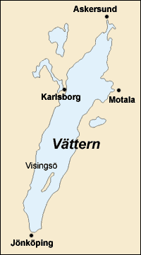
Vättern is the second biggest lake in Sweden. The lake's total surface area is about 1,912 km2 (738 sq mi) . The deepest known point is 128 m (420 ft). The average depth of the lake is 40 m (131 ft).
Vättern is famous for the quality of its transparent water. Many of the people living in the area get their drinking water directly from Vättern. The lake water does not need to have many things done to it before it is used in nearby cities and towns. The water can be safely drunk from almost any point in the lake. It has been said that Vättern is the largest body of potable water in the world.
Vättern is also noted for its fishing. Tourist sport fishermen and people on vacation are allowed to fish in the lake as long as they do not use nets.
References
[change | change source]- ↑ 1.0 1.1 1.2 1.3 1.4 1.5 Seppälä, Matti (2005). The Physical Geography of Fennoscandia. Oxford University Press. p. 145. ISBN 978-0-19-924590-1.
Other websites
[change | change source]
