Uíge Province
Appearance
Uige Uije | |
|---|---|
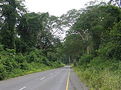
 Caxito-Uíge Road | |
 Map of Angola with the Uige province highlighted | |
| Coordinates: 7°37′S 15°03′E / 7.617°S 15.050°E | |
| Country | Angola |
| Alvor Agreement | January 15, 1975 |
| Capital | Uige |
| Area | |
| • Land | 22,663 km2 (8,750 sq mi) |
| Population | |
| • Total | 800,000 |
Uíge (pronounced: "Weej"), [1] is one of the eighteen provinces of Angola.[2] It is in the northwestern part of the country.[3] The capital city is Uíge. There are 500,000 people. The Beu Forest Reserve is in the province.
The province was badly damaged during the long civil war. Many buildings were destroyed. Many people had to move.
References
[change | change source]- ↑ Benarde, Melvin A. (2006). Our precarious habitat?: the sky is not falling. Wiley-Interscience. pp. 104–. ISBN 9780471740650. Retrieved 21 January 2011.
- ↑ James, pp. 135 ff
- ↑ "Uige". Encyclopædia Britannica. Retrieved 21 January 2011.
