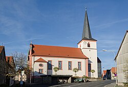
Stadtlauringen
Appearance
Stadtlauringen | |
|---|---|
 Church of Saint John the Baptist | |
| Coordinates: 50°11′17″N 10°21′34″E / 50.18806°N 10.35944°E | |
| Country | Germany |
| State | Bavaria |
| Admin. region | Unterfranken |
| District | Schweinfurt |
| Subdivisions | 10 Ortsteile |
| Government | |
| • Mayor (2020–26) | Friedel Heckenlauer[1] (CSU) |
| Area | |
| • Total | 63.62 km2 (24.56 sq mi) |
| Elevation | 290 m (950 ft) |
| Population (2022-12-31)[2] | |
| • Total | 4,155 |
| • Density | 65/km2 (170/sq mi) |
| Time zone | UTC+01:00 (CET) |
| • Summer (DST) | UTC+02:00 (CEST) |
| Postal codes | 97488 |
| Dialling codes | 09724 |
| Vehicle registration | SW |
| Website | www.stadtlauringen.de |
Stadtlauringen is a municipality in Schweinfurt in Bavaria, Germany.
Geography
[change | change source]Place
[change | change source]Stadtlauringen is in the Main Rhön region, about 20 kilometers north east of Schweinfurt. It is the northernmost municipality in Schweinfurt. The Lauer flows through it. The Ellertshäuser See is close to the village Altenmünster.
Towns and Villages
[change | change source]The municipality Stadtlauringen has the following towns and villages:
- Altenmünster with Ellertshausen and Reinhardshausen
- Ballingshausen
- Birnfeld
- Fuchsstadt
- Mailes
- Oberlauringen
- Stadtlauringen
- Sulzdorf
- Wettringen
- Wetzhausen
Sources
[change | change source]- Reinhold W. F. Heusinger: Markt Stadtlauringen. Beiträge zur Heimatgeschichte. Markt Stadtlauringen, Stadtlauringen 1994. (in German)
References
[change | change source]- ↑ Liste der ersten Bürgermeister/Oberbürgermeister in kreisangehörigen Gemeinden, Bayerisches Landesamt für Statistik, 15 July 2021.
- ↑ Genesis Online-Datenbank des Bayerischen Landesamtes für Statistik Tabelle 12411-003r Fortschreibung des Bevölkerungsstandes: Gemeinden, Stichtag (Einwohnerzahlen auf Grundlage des Zensus 2011) .


