Nièvre
Nièvre | |
|---|---|
 Prefecture building of the Nièvre department, in Nevers | |
 Location of Nièvre in France | |
| Coordinates: 47°05′N 03°30′E / 47.083°N 3.500°E | |
| Country | France |
| Region | Bourgogne-Franche-Comté |
| Département | 4 March 1790 |
| Prefecture | Nevers |
| Subprefecture | Château-Chinon, Clamecy, Cosne-Cours-sur-Loire |
| Government | |
| • President | Patrice Joly[1] |
| Area | |
| • Total | 6,816.7 km2 (2,631.9 sq mi) |
| Population (2014)[3] | |
| • Total | 213,569 |
| • Density | 31/km2 (81/sq mi) |
| Demonym | Nivernais |
| Time zone | UTC+1 (CET) |
| • Summer (DST) | UTC+2 (CEST) |
| ISO 3166 code | FR-58 |
| Arrondissements | 4 |
| Cantons | 17 |
| Communes | 309 |
| Website | https://www.nievre.fr |
Nièvre is a department in the centre of France, in the Bourgogne-Franche-Comté region. It is named after the Nièvre river, a tributary of the Loire. Its prefecture and largest city is Nevers.
History
[change | change source]Nièvre is one of the original 83 departments created during the French Revolution on 4 March 1790 with Nevers as its capital. It was formed from part of the old province of Nivernais and its name was written at first as Nyèvre.[4]
It was divided in nine districts: Nevers, Saint-Pierre-le-Moutier, Decize, Moulins-Engilbert, Château-Chinon, Corbigny, Clamecy, Cosne and La Charité.
In 1800, with the creation of the arrondissements in France, the nine districts were changed into four arrondissements: Nevers, Château-Chinon, Clamecy and Cosne.[5]
On 10 September 1926, the arrondissement of Cosne was eliminated but in 1943 it became again an arrondissement of the department.[5]
Geography
[change | change source]
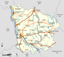
Nièvre is part of the Bourgogne-Franche-Comté region. It has an area of 6,816.7 km2 (2,632 sq mi).[2] The highest point of the department is Mont Préneley (46°57′24″N 4°0′7″E / 46.95667°N 4.00194°E), 855 m (2,805 ft) high;[6] it is in the commune Glux-en-Glenne.
The department borders with six departments in three regions:
- Bourgogne-Franche-Comté region
- Yonne (north)
- Côte-d'Or (east)
- Saône-et-Loire (southeast)
- Auvergne-Rhône-Alpes region
- Allier (southwest)
- Centre-Val de Loire region
There are three main geographical zones in the department:[7]
- Eastern zone, with small hills covered with forests; here is the Parc Naturel Régional du Morvan ("Morvan regional natural park").
- Central zone, an agricultural zone.
- Western zone, a zone organised along a north-south line formed by the valley of the Loire river; it is the zone of the department with higher population.
The main rivers in the department are the Loire, that makes most of the western border, with its tributaries Allier and Aron; and the Yonne, with its tributary Cure.
Climate
[change | change source]The Köppen climate classification type for the climate at Nevers is an "Oceanic climate" (also known as Maritime Temperate climate) and of the subtype "Cfb".[8]
It rains in all seasons but precipitations are more important in the eastern zone, in the Morvan, and weaker in the Loire valley.[9]
Administration
[change | change source]Nièvre is managed by the Departmental Council of Nièvre in Nevers. The department is part of the Bourgogne-Franche-Comté region.
Administrative divisions
[change | change source]There are 4 arrondissements (districts), 17 cantons and 309 communes (municipalities) in Nièvre.[10]
| INSEE code |
Arrondissement | Capital | Population[11] (2014) |
Area[12] (km²) |
Density (Inh./km²) |
Communes |
|---|---|---|---|---|---|---|
| 581 | Château-Chinon (Ville) | Château-Chinon (Ville) | 25,717 | 1,929.1 | 13.3 | 80 |
| 582 | Clamecy | Clamecy | 24,993 | 1,464.0 | 17.1 | 84 |
| 583 | Nevers | Nevers | 118,087 | 2,020.3 | 58.5 | 82 |
| 584 | Cosne-Cours-sur-Loire | Cosne-Cours-sur-Loire | 44,772 | 1,403.3 | 31.9 | 63 |
The following is a list of the 17 cantons of the Nièvre department (with their INSEE codes), following the French canton reorganisation which came into effect in March 2015:[13]
- La Charité-sur-Loire (5801)
- Château-Chinon (5802)
- Clamecy (5803)
- Corbigny (5804)
- Cosne-Cours-sur-Loire (5805)
- Decize (5806)
- Fourchambault (5807)
- Guérigny (5808)
- Imphy (5809)
- Luzy (5810)
- Nevers-1 (5811)
- Nevers-2 (5812)
- Nevers-3 (5813)
- Nevers-4 (5814)
- Pouilly-sur-Loire (5815)
- Saint-Pierre-le-Moûtier (5816)
- Varennes-Vauzelles (5817)
Demographics
[change | change source]The inhabitants of Nièvre are known, in French, as Nivernais (women: Nivernaises).[14]
Nièvre had a population, in 2014, of 213,569,[3] for a population density of 31.3 inhabitants/km2. The arrondissement of Nevers, with 118,087 inhabitants, is the arrondissement with more inhabitants.[11]
Evolution of the population in Nièvre

The 10 communes with more inhabitants in the department are:[11]
| City | Population[11] (2014) |
Arrondissement |
|---|---|---|
| Nevers | 34,485 | Nevers |
| Cosne-Cours-sur-Loire | 10,553 | Cosne-Cours-sur-Loire |
| Varennes-Vauzelles | 9,467 | Nevers |
| Decize | 5,626 | Nevers |
| La Charité-sur-Loire | 5,008 | Cosne-Cours-sur-Loire |
| Fourchambault | 4,456 | Nevers |
| Clamecy | 3,889 | Clamecy |
| Garchizy | 3,835 | Nevers |
| Marzy | 3,656 | Nevers |
| Coulanges-lès-Nevers | 3,591 | Nevers |
Gallery
[change | change source]-
Ducal Palace in Nevers
-
Notre-Dame of La Charité-sur-Loire
-
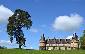
Château de Villemolin, Anthien
-
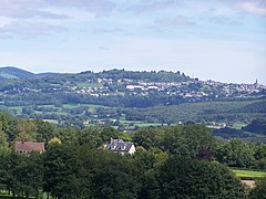
Château-Chinon (Ville): view from Dommartin
-
Bridge over the Loire, at Cosne-Cours-sur-Loire
Related pages
[change | change source]References
[change | change source]- ↑ "Le Président du Conseil Départemental" (in French). Conseil Départemental de la Nièvre. Archived from the original on 6 June 2017. Retrieved 10 June 2017.
- ↑ 2.0 2.1 "Département de la Nièvre (58)". Comparateur de territoire (in French). Institut national de la statistique et des études économiques - INSEE. Retrieved 10 June 2017.
- ↑ 3.0 3.1 "Populations légales 2014: Recensement de la population - Régions, départements, arrondissements, cantons et communes" (in French). Institut national de la statistique et des études économiques - INSEE. Retrieved 10 June 2017.
- ↑ "Description de la Nièvre". Le SPLAF (in French). Retrieved 5 October 2014.
- ↑ 5.0 5.1 "Historique de la Nièvre". Le SPLAF (in French). Retrieved 5 October 2014.
- ↑ "Mont Préneley, France". Peakbagger.com. Retrieved 10 June 2017.
- ↑ "Situation géographique de la Nièvre". CG58.fr. Conseil Général de la Nièvre. Archived from the original on 24 December 2015. Retrieved 5 October 2014.
- ↑ "Nevers, France - Köppen Climate Classification". Weatherbase. Retrieved 5 October 2014.
- ↑ "Chiffres-Clés". CG58.fr. Conseil Général de la Nièvre. Archived from the original on 24 December 2014. Retrieved 5 October 2014.
- ↑ "Département de la Nièvre (58)". Géographie administrative et d'étude (in French). Institut national de la statistique et des études économiques - INSEE. Retrieved 10 June 2017.
- ↑ 11.0 11.1 11.2 11.3 "Régions, départements, arrondissements, cantons et communes" (PDF). Populations légales 2014 (in French). Institut national de la statistique et des études économiques - INSEE. Retrieved 10 June 2017.
- ↑ "Département de la Nièvre (58)". Comparateur de territoire (in French). Institut national de la statistique et des études économiques - INSEE. Retrieved 10 June 2017.
- ↑ "Décret n° 2014-184 du 18 février 2014 portant délimitation des cantons dans le département de la Nièvre" (in French). Legifrance.gouv.fr. 18 February 2014. Retrieved 30 April 2015.
- ↑ "Nièvre (58)" (in French). habitants.fr. Retrieved 6 October 2014.
Other websites
[change | change source]- Departmental Council website (in French)
- Prefecture website[permanent dead link] (in French)
- Agence de Développement Touristique de la Nièvre (in French)


