Amazonas (Venezuela)
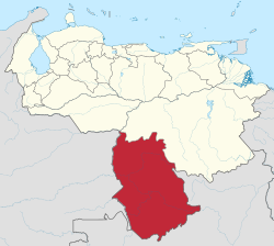


Amazonas is one of the 23 states into which Venezuela is divided. Amazonas State covers a total surface area of 176,899 km² and, in 2007, had a population of 142,200.[1][2]
The state capital is Puerto Ayacucho. Amazonas has Venezuela's highest proportion of indigenous peoples of Venezuela.[3]
Municipalities and Municipal Seats
[change | change source]| Municipality | Capital | km² | Pop | Map |
|---|---|---|---|---|
| Alto Orinoco Municipality | La Esmeralda | 49.217 km² | 14.222 hab. (2008) | 
|
| Atabapo Municipality | San Fernando de Atabapo | 25.062 km² | 12.797 hab. (2007) | 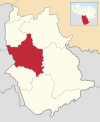
|
| Atures Municipality | Puerto Ayacucho | 7.302 km² | 91.386 hab (2007) | 
|
| Autana Municipality | Isla Ratón | 12.291 km² | 8.181 hab (2007) | 
|
| Manapiare Municipality | San Juan de Manapiare | 32.042 km² | 9.658 hab (2007) | 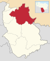
|
| Maroa Municipality | Maroa | 13.082 km² | 8.181 hab (2005) | 
|
| Río Negro Municipality | San Carlos de Río Negro | 37.903 km² | 9.658 hab (2007) | 
|
Geography
[change | change source]Rivers
[change | change source]
In this state comes the main river of Venezuela, the Orinoco, in the mount delgado Chalbaud.[4] Other rivers in the state are: Ventuari river, Yatití, Parú, Asita, Manapiare, Marieta, Guapachí, Ocamo, Putaco, Padamo, Cuntinamo, Botamo, Matacuní, Ugueto, Mavaca, Manaviche, Cunucunuma, Guanane, Yagua, Guaviare, Sipapo, Cataniapo Atabapo, Uesete, Siapa, Ararí, Manipitare, Casiquiare, Pamoni, Pasiba, Pasimoni, Negro and Guainía.[5][6][7]
National parks
[change | change source]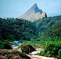
The State of Amazonas has many natural sites of great interest.
- Parima Tapirapeco National Park.[7]
- Serranía La Neblina National Park.[7]
- Yapacana National Park.[7]
- National Park Duida Marahuaca.[7]
Natural monuments
[change | change source]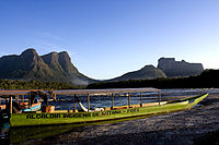
Fauna
[change | change source]The rich fauna of the region is represented by numerous specimens of mammals, reptiles, fish and birds.[7]
- Mammals: puma, jaguar, tapir, monkey, anteater, & fox.
- Reptiles: Orinoco crocodile, baba, turtle, tortoise, snakes, anaconda, tragavenado, cuaima, & mapanare.
- Fish: Sapoara, shaker or electric eel, bay, caribbean, piranha, catfish, and guabina.
- Birds: eagle, harpy eagle, hawk, macaw, katana, carpenter, helmeted, & toucan.
References
[change | change source]- ↑ Vila, Marco Aurelio. 1964: Aspectos Geograficos del Territorio Federal Amazonas. Corporación Venezolana de Fomento. Caracas. 192p.
- ↑ González Niño, Edgardo. 1984: Historia del Territorio Federal Amazonas. Ediciones de la Presidencia de la República. Caracas. 174p.
- ↑ Van Cott (2003), "Andean Indigenous Movements and Constitutional Transformation: Venezuela in Comparative Perspective", Latin American Perspectives 30(1), p52
- ↑ León A, Rafael de. y Rodríguez Díaz, Alberto J. (1976): El Orinoco aprovechado y recorrido. Corporación Venezolana de Guayana y Ministerio de Obras Públicas. Caracas. 216p.
- ↑ Zinck, Alfred. 1986. Venezuelan Rivers. Cuadernos Lagoven Lagoven, S.A. Caracas. 64p. ISBN 980-259-084-3
- ↑ Gines, H. 1992: Los grandes ríos suramericanos. Ediciones Corpoven. Caracas. 44p. ISBN 980-259-534-9
- ↑ 7.00 7.01 7.02 7.03 7.04 7.05 7.06 7.07 7.08 7.09 Hernández Caballero, Serafín (Editor). (1998): Gran Enciclopedia de Venezuela. Editorial Globe, C.A. Caracas. 10 volúmenes. ISBN 980-6427-00-9 ISBN 980-6427-10-6
Other websites
[change | change source]- Governor's page Archived 2005-11-19 at the Wayback Machine
