Abruzzo
Abruzzo | |
|---|---|
 | |
| Country | Italy |
| Capital | L'Aquila |
| Government | |
| • President | Giovanni Lolli, ad interim (Democratic) |
| Area | |
| • Total | 10,763 km2 (4,156 sq mi) |
| Population (2012-10-31) | |
| • Total | 1,307,919 |
| • Density | 120/km2 (310/sq mi) |
| Demonym | Abruzzan(s) / Abruzzese / Abruzzesi |
| Time zone | UTC+1 (CET) |
| • Summer (DST) | UTC+2 (CEST) |
| GDP/ Nominal | €28.7[1] billion (2008) |
| GDP per capita | €21,400[2] (2008) |
| NUTS Region | ITF |
| Website | www.regione.abruzzo.it |
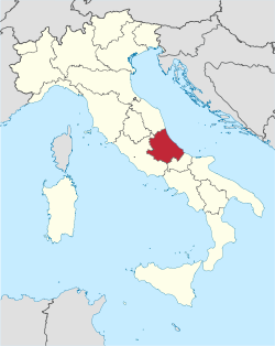
Abruzzo is one of the twenty regions of Italy, in Southern Italy on the Adriatic Sea. The capital is the city of L'Aquila.
Geography
[change | change source]The region is located in Southern Italy bordered by Marche to the north, Lazio to the west, Molise to the south and the Adriatic Sea to the east.
Abruzzo is the 13th largest region in Italy, with a total area of 10,831.84 km2 (4,182.2 sq mi).[3] The main rivers in the region are:
- Aterno-Pescara, 152 km (94.4 mi) long.
- Sangro, 122 km (75.8 mi) long.
- Vomano, 76 km (47.2 mi) long.
- Tordino, 59 km (36.7 mi) long.
- Liri, 120 km (74.6 mi) long, 40 km (24.9 mi) in Abruzzo.
The Tronto river is 115 km (71.5 mi) long but flows mainly in the Marche region.
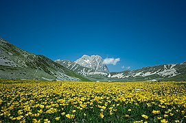
The highest mountain in the region is Corno Grande (42°28′10″N 13°33′56″E / 42.46944°N 13.56556°E), in the Teramo province, with an altitude of 2,912 m (9,554 ft).[4]
Provinces
[change | change source]The region is divided into four provinces:
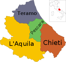
| Province | Abbreviation | Capital | Area (km²) |
Population[5] (1 January 2017) |
Density (inh./km²) |
Comuni |
|---|---|---|---|---|---|---|
| Chieti | CH | Chieti | 2,599.58 | 389,169 | 149.7 | 104 |
| L'Aquila | AQ | L'Aquila | 5,047.55 | 301,910 | 59.8 | 108 |
| Pescara | PE | Pescara | 1,230.33 | 321,309 | 261.2 | 46 |
| Teramo | TE | Teramo | 1,954.38 | 309,859 | 158.5 | 47 |
| Total | 10,831.84 | 1,322.247 | 140.6 | 305 | ||
Largest municipalities
[change | change source]The 10 comuni of the region with more people living in it are:
| No. | Comuni | Province | Population[5] (2017) |
Area[6](km2) | Density (inh./km2) |
|---|---|---|---|---|---|
| 1 | Pescara | PE | 120,420 | 34.36 | 3,504.7 |
| 2 | L'Aquila | AQ | 69,605 | 473.91 | 146.9 |
| 3 | Teramo | TE | 54,775 | 152.84 | 358.4 |
| 4 | Montesilvano | PE | 54,152 | 23.57 | 2,297.5 |
| 5 | Chieti | CH | 51,330 | 59.57 | 861.7 |
| 6 | Avezzano | AQ | 42,509 | 104.09 | 408.4 |
| 7 | Vasto | CH | 41,283 | 71.35 | 578.6 |
| 8 | Lanciano | CH | 35,251 | 66.94 | 526.6 |
| 9 | Roseto degli Abruzzi | TE | 25,602 | 53.27 | 480.6 |
| 10 | Francavilla al Mare | CH | 25,520 | 23.09 | 1,105.2 |
Gallery
[change | change source]References
[change | change source]- ↑ "Eurostat – Tables, Graphs and Maps Interface (TGM) table". European Commission. 12 August 2011. Retrieved 15 September 2011.
- ↑ "EUROPA Press Releases – Regional GDP per inhabitant in 2008 GDP per inhabitant ranged from 28% of the EU27 average in Severozapaden in Bulgaria to 343% in Inner London". Europa (web portal). Archived from the original on 12 February 2012. Retrieved 8 October 2013.
- ↑ "Abruzzo" (in Italian). Tuttitalia.it. Retrieved 2 October 2017.
- ↑ "Corno Grande, Italy". Peakbagger.com. Retrieved 2 October 2017.
- ↑ 5.0 5.1 "Statistiche demografiche ISTAT" (in Italian). Demo.istat.it. Archived from the original on 3 January 2018. Retrieved 2 October 2017.
- ↑ "Comuni abruzzesi per popolazione" (in Italian). Tuttitalia.it. Retrieved 2 October 2017.
Other websites
[change | change source]- Official Site (in Italian)
- Official Tourist Information Archived 2012-10-05 at the Wayback Machine


