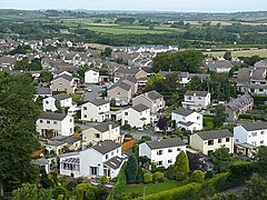
Llanfairpwllgwyngyll
ദൃശ്യരൂപം
| Llanfairpwllgwyngyll | |
|---|---|
 | |
Llanfairpwllgwyngyll shown within Anglesey | |
| Population | 3,107 (2011 UK census) |
| OS grid reference | SH528716 |
| Community |
|
| Principal area | |
| Ceremonial county | |
| Country | Wales |
| Sovereign state | United Kingdom |
| Post town | LLANFAIRPWLLGWYNGYLL |
| Postcode district | LL61 |
| Dialling code | 01248 |
| Police | North Wales |
| Fire | North Wales |
| Ambulance | Welsh |
| EU Parliament | Wales |
| UK Parliament | |
| Welsh Assembly | |
വെയിൽസിലെ ഒരു വലിയ ഗ്രാമമാണ് Llanfairpwllgwyngyll അല്ലെങ്കിൽ Llanfair Pwllgwyngyll (pronounced [ɬanˌvair puɬˈɡwɨ̞nɡɨ̞ɬ]). ചുരുക്കി ഈ പേര് (Llanfairpwll) -നേയും നീട്ടി (Llanfairpwllgwyngyllgogerychwyrndrobwllllantysiliogogogoch), -എന്നും ഉപയോഗിക്കാറുണ്ട്. വെയിൽസിലെ ആൻഗ്ലെസി ദ്വീപിലെ ഒരു പ്രാദേശിക ഭരണകൂടവുംകൂടിയാണിത്.
ചരിത്രം
[തിരുത്തുക]
പേര്
[തിരുത്തുക]സ്ഥലപ്പേരിന്റെ സാംഗത്യം
[തിരുത്തുക]
ഉച്ചാരണം
[തിരുത്തുക]

ജനകീയസംസ്കൃതിയിൽ
[തിരുത്തുക]കാലാവസ്ഥ
[തിരുത്തുക]| Llanfairpwllgwyngyll, 1961–1990, Altitude: 15 metres above mean sea level പ്രദേശത്തെ കാലാവസ്ഥ | |||||||||||||
|---|---|---|---|---|---|---|---|---|---|---|---|---|---|
| മാസം | ജനു | ഫെബ്രു | മാർ | ഏപ്രി | മേയ് | ജൂൺ | ജൂലൈ | ഓഗ | സെപ് | ഒക് | നവം | ഡിസം | വർഷം |
| റെക്കോർഡ് കൂടിയ °C | 16 | 17 | 22 | 24 | 28 | 29 | 31 | 34 | 27 | 25 | 18 | 17 | 34 |
| ശരാശരി കൂടിയ °C | 7.7 | 8.0 | 9.7 | 12.1 | 15.2 | 17.9 | 19.4 | 19.3 | 17.4 | 14.6 | 10.5 | 8.7 | 13.37 |
| പ്രതിദിന മാധ്യം °C | 5.2 | 5.1 | 6.6 | 8.5 | 11.3 | 14.0 | 15.7 | 15.6 | 13.9 | 11.5 | 7.8 | 6.1 | 10.11 |
| ശരാശരി താഴ്ന്ന °C | 2.6 | 2.2 | 3.4 | 4.9 | 7.4 | 10.1 | 11.9 | 11.9 | 10.4 | 8.3 | 5.0 | 3.5 | 6.8 |
| താഴ്ന്ന റെക്കോർഡ് °C | −9 | −8 | −7 | −3 | −1 | 2 | 5 | 4 | 1 | −1 | −4 | −8 | −9 |
| വർഷപാതം mm | 107 | 72 | 85 | 65 | 65 | 68 | 74 | 95 | 98 | 120 | 130 | 123 | 1,102 |
| റെക്കോർഡ് കൂടിയ °F | 61 | 63 | 72 | 75 | 82 | 84 | 88 | 93 | 81 | 77 | 64 | 63 | 93 |
| ശരാശരി കൂടിയ °F | 45.9 | 46.4 | 49.5 | 53.8 | 59.4 | 64.2 | 66.9 | 66.7 | 63.3 | 58.3 | 50.9 | 47.7 | 56.08 |
| പ്രതിദിന മാധ്യം °F | 41.4 | 41.2 | 43.9 | 47.3 | 52.3 | 57.2 | 60.3 | 60.1 | 57 | 52.7 | 46 | 43 | 50.2 |
| ശരാശരി താഴ്ന്ന °F | 36.7 | 36 | 38.1 | 40.8 | 45.3 | 50.2 | 53.4 | 53.4 | 50.7 | 46.9 | 41 | 38.3 | 44.23 |
| റെക്കോർഡ് താഴ്ന്ന °F | 16 | 18 | 19 | 27 | 30 | 36 | 41 | 39 | 34 | 30 | 25 | 18 | 16 |
| മഴ inches | 4.21 | 2.83 | 3.35 | 2.56 | 2.56 | 2.68 | 2.91 | 3.74 | 3.86 | 4.72 | 5.12 | 4.84 | 43.38 |
| ശരാ. മഴ ദിവസങ്ങൾ (≥ 0.2 mm) | 19.7 | 15.0 | 18.9 | 14.1 | 18.9 | 13.7 | 13.1 | 15.1 | 15.8 | 18.7 | 19.5 | 19.5 | 202 |
| ശരാ. മഞ്ഞു ദിവസങ്ങൾ | 2.9 | 3.1 | 1.7 | 0.7 | 0.1 | 0.0 | 0.0 | 0.0 | 0.0 | 0.0 | 0.4 | 1.6 | 10.5 |
| മാസം സൂര്യപ്രകാശം ലഭിക്കുന്ന ശരാശരി മണിക്കൂറുകൾ | 49.6 | 73.5 | 105.4 | 153.0 | 195.3 | 183.0 | 173.6 | 164.3 | 126.0 | 93.0 | 57.0 | 40.3 | 1,414 |
| ഉറവിടം: Met Office[2] | |||||||||||||
| Llanfairpwllgwyngyll, 1961–1990, Altitude: 15 metres above mean sea level പ്രദേശത്തെ കാലാവസ്ഥ | |||||||||||||
|---|---|---|---|---|---|---|---|---|---|---|---|---|---|
| മാസം | ജനു | ഫെബ്രു | മാർ | ഏപ്രി | മേയ് | ജൂൺ | ജൂലൈ | ഓഗ | സെപ് | ഒക് | നവം | ഡിസം | വർഷം |
| ശരാ. മഴ ദിവസങ്ങൾ (≥ 1.0 mm) | 15.6 | 11.2 | 13.0 | 10.4 | 10.9 | 10.3 | 9.4 | 11.7 | 12.3 | 15.0 | 15.7 | 15.1 | 150.6 |
| ഉറവിടം: Met Office[2] | |||||||||||||
| Llanfairpwllgwyngyll, 1961–1990, Altitude: 15 metres above mean sea level പ്രദേശത്തെ കാലാവസ്ഥ | |||||||||||||
|---|---|---|---|---|---|---|---|---|---|---|---|---|---|
| മാസം | ജനു | ഫെബ്രു | മാർ | ഏപ്രി | മേയ് | ജൂൺ | ജൂലൈ | ഓഗ | സെപ് | ഒക് | നവം | ഡിസം | വർഷം |
| ശരാ. മഴ ദിവസങ്ങൾ (≥ 10.0 mm) | 2.5 | 1.7 | 2.0 | 1.5 | 1.2 | 1.6 | 2.2 | 2.7 | 2.8 | 3.4 | 3.8 | 3.5 | 28.9 |
| ഉറവിടം: Met Office[2] | |||||||||||||
ശ്രദ്ധേയരായ ആൾക്കാർ
[തിരുത്തുക]- Wilfred Mitford Davies (1895–1966) Welsh artist and publisher, went to school in the town
- Sir John "Kyffin" Williams, KBE, RA (1918–2006) Welsh landscape painter, lived at Pwllfanogl, Llanfairpwll
- John Lasarus Williams (1924–2004), known as John L, was a Welsh nationalist activist.
- Naomi Ellen Watts (born 1968) is an English actress and film producer, lived in the town as a child
- Taron Egerton (born 1989) is a Welsh actor, went to school in the town
- Siobhan Owen (born 1993) soprano and harpist from Adelaide, emigrated aged two
- Elin Fflur (born 1986) is a Welsh Pop singer, TV Presenter, and Radio broadcaster
ഇതും കാണുക
[തിരുത്തുക]- Llanfairpwll F.C., the village's football club
- List of long place names
അവലംബം
[തിരുത്തുക]- ↑ "Llanfairpwll Community Council". www.llanfairpwll.org. Archived from the original on 7 ഫെബ്രുവരി 2019. Retrieved 8 ജൂൺ 2018.
- ↑ 2.0 2.1 2.2 "Example climate estimate". Met Office. Archived from the original on 5 സെപ്റ്റംബർ 2015. Retrieved 8 ജൂൺ 2018.


