A nice collection of free #GIS data sources "10 𝐅𝐫𝐞𝐞 𝐆𝐈𝐒 𝐃𝐚𝐭𝐚 𝐒𝐨𝐮𝐫𝐜𝐞𝐬: 𝐁𝐞𝐬𝐭 𝐆𝐥𝐨𝐛𝐚𝐥 𝐑𝐚𝐬𝐭𝐞𝐫 𝐚𝐧𝐝 𝐕𝐞𝐜𝐭𝐨𝐫 𝐃𝐚𝐭𝐚𝐬𝐞𝐭𝐬":
- 𝐍𝐚𝐭𝐮𝐫𝐚𝐥 𝐄𝐚𝐫𝐭𝐡 𝐃𝐚𝐭𝐚: https://lnkd.in/diZSdcKt
- 𝐔𝐒𝐆𝐒 𝐄𝐚𝐫𝐭𝐡 𝐄𝐱𝐩𝐥𝐨𝐫𝐞𝐫: https://lnkd.in/daNe97jE
- 𝐎𝐩𝐞𝐧𝐒𝐭𝐫𝐞𝐞𝐭𝐌𝐚𝐩: https://lnkd.in/dRECBK7q
- 𝐄𝐬𝐫𝐢 𝐎𝐩𝐞𝐧 𝐃𝐚𝐭𝐚 𝐇𝐮𝐛: https://hub.arcgis.com/
- 𝐍𝐀𝐒𝐀’𝐬 𝐒𝐨𝐜𝐢𝐨𝐞𝐜𝐨𝐧𝐨𝐦𝐢𝐜 𝐃𝐚𝐭𝐚 𝐚𝐧𝐝 𝐀𝐩𝐩𝐥𝐢𝐜𝐚𝐭𝐢𝐨𝐧𝐬 𝐂𝐞𝐧𝐭𝐞𝐫 (𝐒𝐄𝐃𝐀𝐂): https://lnkd.in/d3YfbMiP
- 𝐎𝐩𝐞𝐧 𝐓𝐨𝐩𝐨𝐠𝐫𝐚𝐩𝐡𝐲: https://opentopography.org
- 𝐔𝐍𝐄𝐏 𝐄𝐧𝐯𝐢𝐫𝐨𝐧𝐦𝐞𝐧𝐭𝐚𝐥 𝐃𝐚𝐭𝐚 𝐄𝐱𝐩𝐥𝐨𝐫𝐞𝐫: https://lnkd.in/dXN9gMgD
- 𝐍𝐀𝐒𝐀 𝐄𝐚𝐫𝐭𝐡 𝐎𝐛𝐬𝐞𝐫𝐯𝐚𝐭𝐢𝐨𝐧𝐬 (𝐍𝐄𝐎): https://neo.gsfc.nasa.gov
- 𝐒𝐞𝐧𝐭𝐢𝐧𝐞𝐥 𝐒𝐚𝐭𝐞𝐥𝐥𝐢𝐭𝐞 𝐃𝐚𝐭𝐚: https://lnkd.in/dJmAy47y
- 𝐓𝐞𝐫𝐫𝐚 𝐏𝐨𝐩𝐮𝐥𝐮𝐬: https://terra.ipums.org
𝐑𝐞𝐚𝐝 𝐭𝐡𝐞 𝐟𝐮𝐥𝐥 𝐚𝐫𝐭𝐢𝐜𝐥𝐞 𝐡𝐞𝐫𝐞: https://lnkd.in/dFbCFwcK


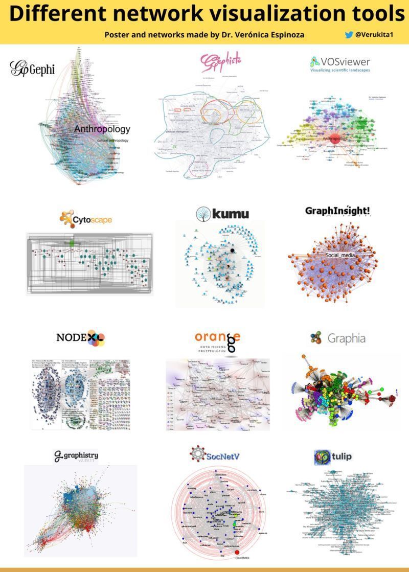
- Geph - https://gephi.org
- Gephisto- https://lnkd.in/diSp3BWN
- VOSviewer - https://www.vosviewer.com
- Cytoscape - https://cytoscape.org
- Kumu - https://kumu.io
- GraphInsight - https://lnkd.in/d5XnkWJr
- NodeXL - https://nodexl.com
- Orange - https://lnkd.in/dZU8Zx3D
- Graphia - https://graphia.app
- Graphistry - https://www.graphistry.com
- SocNetV - https://socnetv.org
- Tulip - https://lnkd.in/dtc_BD33

- networkx - https://lnkd.in/dKCCXjif
- graphviz - https://lnkd.in/dtrTeqRv
- pydot - https://lnkd.in/dA46YZvy
- python-igraph - https://lnkd.in/dCGsRXh2
- pyvis - https://lnkd.in/dVrQ64nN
- ipycytoscape - https://lnkd.in/d-hJjDdG
- pygsp - https://lnkd.in/dS7s-A_v
- graph-tool - https://lnkd.in/dvytUzdu
- nxviz - https://lnkd.in/duHbKGPN
- py2cytoscape - https://lnkd.in/dWUU8TZH
- ipydagred3 - https://lnkd.in/diXgFWMD
- ipysigma - https://lnkd.in/dP55J5et
- Py3Plex - https://lnkd.in/dhwe7f_g
- net wulf - https://lnkd.in/dxrHAm2P
-
Extracting building footprints Instance Segmentation Models: MaskRCNN
-
Identifying new construction Change Detection Models: STA-Net ChangeDetector
-
Classifying homes as damaged or not after a forest fire Object Classification Models: FeatureClassifier with ResNet, Inception, VGG backbones
-
Detecting swimming pools Object Detection Models: SingleShotDetector(SSD), RetinaNet, YOLO, FasterRCNN, MMDetection
-
Road extraction Road Extraction Models: MultiTaskRoadExtractor
-
Crop Classification Imagery Time Series Classification Models: PSETAE
-
Land cover classification Pixel Classification Models: UNetClassifier, PSPNetClassifier, DeepLab, MMSegmentation
-
Mapping residential parcels Edge Detection Models: BDCNEdgeDetector, HEDEdgeDetector, ConnectNet
-
Increasing (upscaling) image resolution Image Enhancement Models: SuperResolution
How to start?
- Prepear your input imagery data, and generate true-ortho with ArcGIS Reality for best accuracy.
- ArcGIS API for Python + arcgis.learn module - Functions for calling the Deep Learning Tools https://lnkd.in/dCfsifZh
- Explore and test pre-trained models - ArcGIS Living Atlas https://lnkd.in/dQsE5FXp
- Use ArcGIS tools to improve or train your own models (see guide in each DLPK)
- Build own Apps & Solutions