Peñón de Ponce
| Peñón de Ponce | |
|---|---|
| Highest point | |
| Elevation | 335 ft (102 m)[1] |
| Prominence | 335 ft (102 m)[2] |
| Coordinates | 17°58′47.4594″N 66°41′54.4806″W / 17.979849833°N 66.698466833°W[3] |
| Geography | |
| Location | Ponce, Puerto Rico |
| Climbing | |
| Easiest route | PR-2, km 220.1, Sector Las Cucharas, Barrio Canas, Ponce, Puerto Rico |
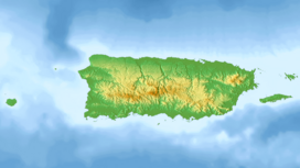
Peñón de Ponce is a boulder[4] in the municipality of Ponce, Puerto Rico, located in the western coastal section of the municipality, in Sector Punta Cucharas, Barrio Canas, immediately north of Puerto Rico Highway 2 (PR-2), kilometer 220.1. The Peñón de Ponce promontory separates the Port of Tallaboa from the plains that give access to the municipality of Ponce.[5]
History
[edit]The hill has been on record at least since 1788 when Íñigo Abbad used it to describe the distance (2 leguas, or 2 hours walking distance) to the village of Ponce relative to this landmark feature.[6]
Location and geology
[edit]The hill is located at coordinates 17° 58' 47.5", -66° 41' 54.5", in an area known to Ponce Cement for its limestone value.[7] There is a correctional center and a Holiday Inn Hotel on neighboring hills.
In the fine arts
[edit]In 1855, poet Federico Matos, father of Felix Matos Bernier and Rafael Matos Bernier, composed the following short poem in Spanish about this hill.[8] The poem, titled "En el Peñón de Ponce", appeared on the 22 May 1858 issue of El Fénix newspaper in Ponce, and was dedicated to Matos's friend Martin Travieso.[9]
En el Peñón de Ponce
|
|
References
[edit]- ^ "Feature Detail Report for: Peñon de Ponce". U.S. Geological Survey. 13 February 1981. Retrieved 11 March 2019.
- ^ "Feature Detail Report for: Peñon de Ponce". U.S. Geological Survey. 13 February 1981. Retrieved 11 March 2019.
- ^ "Peñon de Ponce". Geographic Names Information System. United States Geological Survey, United States Department of the Interior. Retrieved 11 March 2019.
- ^ Francisco Lluch Mora. Orígenes y Fundación de Ponce. San Juan, Puerto Rico: Editorial Plaza Mayor. Second Edition. 2006. p. 65. ISBN 1563281724
- ^ Francisco Lluch Mora. Orígenes y Fundación de Ponce. San Juan, Puerto Rico: Editorial Plaza Mayor. Second Edition. 2006. p. 65. ISBN 1563281724
- ^ Ramon Marín. Las Fiestas Populares de Ponce. Editorial de la Universidad de Puerto Rico. 1994. p. 179.
- ^ Rafael Picó. Nueva Geografía de Puerto Rico: física, económica y social. 1975.
- ^ Emilio J. Pasarell. Esculcando el Siglo XIX en Puerto Rico. Barcelona: Manuel Pareja Press. 1967. pp. 27-28.
- ^ Socorro Guirón. Ponce, el teatro La Perla y La Campana de la Almudaina. Historia de Ponce desde sus comienzos hasta la segunda década del siglo XIX. Ponce, Puerto Rico: Gobierno Municipal de Ponce. 1992. page 91.
Further reading
[edit]- Francisco Lluch Mora. Orígenes y Fundación de Ponce. San Juan, Puerto Rico: Editorial Plaza Mayor. Second Edition. 2006. p. 127. ISBN 1563281724
External links
[edit]- Metereological data at Peñon de Ponce for January 2021 (other dates also available)


