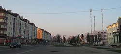
Hantsavichy
Hantsavichy
| |
|---|---|
 | |
| Coordinates: 52°51′27″N 26°28′55″E / 52.85750°N 26.48194°E | |
| Country | Belarus |
| Region | Brest Region |
| District | Hantsavichy District |
| Founded | 1898 |
| Population (2024)[1] | |
• Total | 13,355 |
| Time zone | UTC+3 (MSK) |
| Postal code | 225432 |
| Area code | +375 1646 |
| License plate | 1 |
Hantsavichy or Gantsevichi (Belarusian: Ганцавічы, romanized: Hantsavičy, IPA: [ˈɣant͡savʲitʂɨ]; Russian: Ганцевичи, IPA: [ˈɡantsəvʲɪtɕɪ]; Polish: Hancewicze; Lithuanian: Gancevičai) is a town in Brest Region, Belarus. It serves as the administrative center of Hantsavichy District.[1] As of 2024, it has a population of 13,355.[1]
The Hantsavichy Radar Station is a part of the Russian early warning radar system.
Etymology
[edit]According to Belarusian toponymist Vadzim Žučkievič name "Hantsavichy" comes from surname Hantsavich.[2]
History
[edit]Before World War II, 60% of the population was Jewish. In the 1920s and 1930s there were four synagogues, a Jewish library, an orphanage, a Tarbut school and school in Yiddish. Under Polish administration, in 1939, the town was retaken by the Soviets and annexed to the Byelorussian Soviet Socialist Republic. The German army arrived on June 29, 1941. German occupation of Hantsavichy lasted until 7 July 1944.[citation needed]
From June 30 to July 1, 1941, a pogrom occurred in which 16 Jews were murdered. On August 15, 1941, 350 Jewish men were executed in the forest 11 km away from Hantsavichy. 600 Jews were shot in the town's market place. During another action 1,000 Jewish men were taken to the forest 1 km away and shot dead. A concentration work camp was established in November 1941. Besides the local Jews, there were 230 Lenin Jews and 120 native to Pogost. Small executions of 70-150 Jews took place constantly. During one of those executions, 100 Jewish refugees from Warsaw, along with two local families, Fish and Zeiger, were executed and buried in the Peski ravine. On August 14, 1942, more than 300 Jews fled the camp and others were shot. In all, during the occupation, 3,500 Jews were murdered by the Nazis in the district of Hantsavichy, including 1,500 women and 850 children.[3]
Climate
[edit]| Climate data for Hantsavichy (1991–2020) | |||||||||||||
|---|---|---|---|---|---|---|---|---|---|---|---|---|---|
| Month | Jan | Feb | Mar | Apr | May | Jun | Jul | Aug | Sep | Oct | Nov | Dec | Year |
| Record high °C (°F) | 5.4 (41.7) |
7.6 (45.7) |
15.0 (59.0) |
23.3 (73.9) |
27.7 (81.9) |
30.1 (86.2) |
31.2 (88.2) |
30.9 (87.6) |
26.3 (79.3) |
20.5 (68.9) |
12.9 (55.2) |
7.0 (44.6) |
31.2 (88.2) |
| Mean daily maximum °C (°F) | −1.1 (30.0) |
0.4 (32.7) |
5.9 (42.6) |
13.8 (56.8) |
19.6 (67.3) |
22.8 (73.0) |
24.7 (76.5) |
24.1 (75.4) |
18.4 (65.1) |
11.6 (52.9) |
4.6 (40.3) |
0.2 (32.4) |
12.1 (53.8) |
| Daily mean °C (°F) | −3.6 (25.5) |
−2.8 (27.0) |
1.4 (34.5) |
8.0 (46.4) |
13.6 (56.5) |
17.2 (63.0) |
18.9 (66.0) |
17.9 (64.2) |
12.7 (54.9) |
7.1 (44.8) |
2.1 (35.8) |
−2.0 (28.4) |
7.5 (45.5) |
| Mean daily minimum °C (°F) | −6.0 (21.2) |
−5.6 (21.9) |
−2.4 (27.7) |
2.5 (36.5) |
7.5 (45.5) |
11.1 (52.0) |
13.1 (55.6) |
11.9 (53.4) |
7.6 (45.7) |
3.2 (37.8) |
−0.2 (31.6) |
−4.3 (24.3) |
3.2 (37.8) |
| Record low °C (°F) | −20.0 (−4.0) |
−17.8 (0.0) |
−12.1 (10.2) |
−4.9 (23.2) |
−0.4 (31.3) |
4.1 (39.4) |
7.3 (45.1) |
5.1 (41.2) |
−0.7 (30.7) |
−5.2 (22.6) |
−9.9 (14.2) |
−15.3 (4.5) |
−20.0 (−4.0) |
| Average precipitation mm (inches) | 39.1 (1.54) |
34.7 (1.37) |
36.6 (1.44) |
41.2 (1.62) |
66.4 (2.61) |
78.3 (3.08) |
94.8 (3.73) |
58.7 (2.31) |
50.2 (1.98) |
46.4 (1.83) |
44.9 (1.77) |
42.1 (1.66) |
633.4 (24.94) |
| Average precipitation days (≥ 1.0 mm) | 9.7 | 9.4 | 8.7 | 7.4 | 9.9 | 10.2 | 10.7 | 7.3 | 7.1 | 7.9 | 9.0 | 9.9 | 107.2 |
| Source: NOAA[4] | |||||||||||||
Population
[edit]- 1897 — 633[5]
- 1909 — 1026[6]
- 1970 — 5 200[7]
- 1973 — 6 900
- 1991 — 14 500[8]
- 2006 — 14 700
- 2008 — 14 800
- 2015 - 14 043[9]
Education
[edit]There are 3 schools, 1 gymnasium, agricultural lyceum and a special boarding school in Hantsavichy.[citation needed]
References
[edit]- ^ a b c "Численность населения на 1 января 2024 г. и среднегодовая численность населения за 2023 год по Республике Беларусь в разрезе областей, районов, городов, поселков городского типа". belsat.gov.by. Archived from the original on 2 April 2024. Retrieved 11 June 2024.
- ^ Жучкевіч, В. (1974). Кароткі тапанімічны слоўнік Беларусі. Мінск: Выдавецтва БДУ.
- ^ "Yahad - in Unum".
- ^ "World Meteorological Organization Climate Normals for 1991-2020 — Hantsavichy". National Oceanic and Atmospheric Administration. Retrieved January 12, 2024.
- ^ Малішэўскі, У.А.; Пабока, П.М. (1991). Ганцавічы // Нашы гарады: грамадска-палітычнае даведачнае выданне. Мінск: Народная асвета.
- ^ Віталь Герасіменя. Першыя крокі на Ганцавіцкі краязнаўчы музэй
- ^ Прохоров, А.М. (1969). Большая советская энциклопедия, 3-е изд.: в 30 т.. Москва: Советская энциклопедия.
- ^ Шишков, В.П. (1998). Большой энциклопедический словарь. Москва: НИ «Большая Российская энциклопедия».
- ^ Statistical Bulletin «Численность населения на 1 января 2015 г. и среднегодовая численность населения за 2014 год по Республике Беларусь в разрезе областей, районов, городов, поселков городского типа».


