The Ganges Canal or Ganga Canal is a canal system that irrigates the Doab region between the Ganges River and the Yamuna River in India. The canal is primarily an irrigation canal, although parts of it were also used for navigation, primarily for its construction materials. Separate navigation channels with lock gates were provided on this system for boats to negotiate falls. Originally constructed from 1842 to 1854, for an original head discharge of 6000 ft³/s, the Upper Ganges Canal has since been enlarged gradually for the present head discharge of 10,500 ft³/s (295 m³/s). The system consists of main canal of 272 miles and about 4000 miles long distribution channels. The canal system irrigates nearly 9,000 km² of fertile agricultural land in ten districts of Uttar Pradesh and Uttarakhand. Today the canal is the source of agricultural prosperity in much of these states, and the irrigation departments of these states actively maintain the canal against a fee system charged from users.
There are some small hydroelectric plants on the canal capable of generating about 33MW if running at full capacity these are at Nirgajini, Chitaura, Salawa, Bhola, Jani, Jauli and Dasna.[2][3]
The canal is administratively divided into the Upper Ganges Canal from Haridwar to Aligarh, with some branches, and the Lower Ganges Canal which constitutes several branches below Aligarh.
A channel from Chaudhary Charan Singh Ganga barrage at Narora (Bulandshahr district) intersects the canal system 48 kms downstream from Nanau (Aligarh district), and continues past the Sengar River and Sarsa river, past Shikohabad in Firozabad District to become the Bhognipur branch which was opened in 1880. This branch, starting at village Jera in Mainpuri district, runs for 166 km to reach Kanpur. At kilometre 64 the Balrai escape carries excess water through a 6.4 km. channel through the ravines to discharge into the Yamuna. This branch has 386 km. of distributary channels. The Bhognipur branch, together with the Kanpur and Etawah branches, is known as the Lower Ganges Canal. The old channels of the old Kanpur and Etawah branches between Nanau and the point of intersection by the channel from Narora, are known as "stumps", and are utilized only when the supply of water in the lower Ganges system runs low.[4] The main branch of the river passes Kanpur (behind IIT Kanpur campus) before breaking into several branches. A branch of it terminates Kanpur Jal Sansthan which comes from behind J. K. Temple.
A new 66 KMs long canal was proposed in 2011 to be constructed to help the farmers of Moradabad, Amroha, and Sambhal districts of the Doab region between the Ganges and Yamuna rivers. Initially, Rs 1,100 crore was allocated to the project in 2011 but by 2021, the project cost was increased to Rs 4,417 cr. Roughly, 410,348 farmers of 1,850 villages in almost 146,532 hectare culturable command area in and around Amroha, Joya, Dhanaura, Gajrauli, Hasanpur, and Gangeshwari blocks of Amroha district, Sambhal, Baniyakheda, Panwasa, Asmauli, and Bahjaoi blocks of Sambhal district, as well as the Dingarpur block of Moradabad district. As of May 2024, The central ganga canal is yet to be officially opened to use, though construction has been completed. [5]
Solani Aqueduct was constructed by an Irish architect John David William Holmes in 1846 at present day Roorkee in the state of Uttarakhand. At the time of opening of the aqueduct, It was considered as the most remarkable brick masonry structure in the world. This 750 foot long, 175 foot wide masonary aqueduct carries the Upper Ganges canal over the Solani River and its river bed contains an average diameter of 0.25 millimetres of sand. Moreover, it has the capability of carrying flood flow of 80,000 cusecs. The reason behind its construction was the inspiration from Alcantara Aqueduct in Portugal.[6]
An irrigation system was felt necessary after the disastrous Agra famine of 1837–38, in which nearly 800,000 people died, and nearly ten million rupees was spent on relief works, resulting in considerable loss of revenue to the British East India Company. One of the moving forces behind the canal was Colonel Proby Cautley, who was confident that a 500-kilometre canal was feasible. There were many obstacles and objections to his project, mostly financial, but Cautley persevered and after spending six months walking and riding through the area taking measurements, he managed to persuade the British East India Company to sponsor the project. This project was sanctioned in 1841, but the work was not begun till 1843, and even then Cautley found himself hampered in its execution by the opposition of Lord Ellenborough.[8]
Digging of the canal began in April 1842.[9] Cautley had to make his own bricks, brick kiln and mortar. Initially, he was opposed by the Hindu priests at Haridwar, who felt that the waters of the holy river Ganges would be imprisoned but Cautley pacified them by agreeing to leave a gap in the dam from where the water could flow unchecked. He further appeased the priests by undertaking the repair of bathing ghats along the river. He also inaugurated the dam by the worship of Lord Ganesh, the god of good beginnings. The dam was faced with many complications- among them was the problem of the mountainous streams that threatened the canal. Near Roorkee, the land fell away sharply and Cautley had to build an aqueduct to carry the canal for half a kilometre. As a result, at Roorkee the canal is 25 metres higher than the original river. When the canal formally opened on 8 April 1854,[9]it was the largest and costliest man-made waterway in the world, its main channel was 348 miles (560 km) long, its branches 306 miles (492 km) long and the various tributaries over 3,000 miles (4,800 km) long. After irrigation was commenced in May 1855,[9] over 767,000 acres (3,100 km2) in 5,000 villages were irrigated.
In 1877 the whole canal system of the lower Doabs underwent radical alteration. The Lower Ganges Canal, with a feed from a channel from Narora, was constructed into the ghar tract of Etawah, and became the Bhognipur branch. Around 1900, according to the Nuttall Encyclopedia of 1907, it had a total extent of 3,700 miles (6,000 km), of which 500 miles (800 km) were navigable. Building of this canal also eventually led to the establishment of first engineering college in India,[10] the College of Civil Engineering at Roorkee (Now Indian Institute of Technology, Roorkee).[11]
The construction of the Ganges Canal required a massive workforce, which was primarily composed of Indian laborers. These workers faced gruelling conditions, including long hours, inadequate wages, poor living conditions, and the absence of medical care. The oppressive working environment was exacerbated by the colonial authorities' indifference to the laborers' well-being. In 1848, dissatisfaction among the workers reached a tipping point, leading to a labor strike. The primary grievances included unfair wage practices, the lack of compensation for injuries, and the general harshness of the working conditions. The laborers demanded better wages and improved working conditions, seeking redress for the exploitation they had endured.[9] The strike was a significant event, as it disrupted the construction of the canal, causing delays and financial losses. The colonial administration, initially unprepared for such organized resistance, responded with a combination of repression and negotiation. British authorities used force to break the strike, deploying police to intimidate and, in some cases, violently suppress the laborers. However, the persistence of the workers' demands forced the administration to make some concessions. In the aftermath of the strike, there were marginal improvements in the wages and working conditions of the laborers. The colonial government recognized the necessity of maintaining labor peace to complete the canal on schedule. While the concessions were limited, they represented a significant acknowledgment of the laborers' grievances and their capacity for collective action. The labor strike during the building of the Ganges Canal was a significant episode in the history of colonial India. It highlighted the harsh realities faced by Indian laborers under British rule and their capacity for resistance against exploitation. The event not only disrupted the canal's construction but also prompted a re-evaluation of labor practices by the colonial administration. Ultimately, the strike stands as a testament to the resilience and agency of Indian laborers, and it provides valuable insights into the complexities of colonial labor relations and the socio-economic impact of British infrastructure projects in India.[8] Later, Proby Cautley wrote a book Report on the Ganges Canal Works: from their commencement until the opening of the Canal in 1854. and mentioned that the Indian labours were "the most intractable and troublesome class of people that were on the works”.[8]
The Ganges canal was primarily built to manage the flood water and to use it for irrigation purposes, but due to constant slippage of water over the course of time has created wetlands like ecosystem and also have helped to recharge the ground water. A survey conducted by the Wildlife Institute of India over the course of the Ganges canal has found that the canal's water supply over the last 184 years has led the formation of variety of habitats and ecosystems, thus functioning as a man-made river, harbouring multiple species- both flora and fauna, which helped in to the sustainable development goals/biodiversity targets. The survey has recorded 64 species of birds including black-bellied tern, Common pochard, 2 species of crocodiles including gharials, 10 species of turtles including red-crowned roofed turtle, endangered Indian narrow-headed softshell turtle, 3 species of mammals, 82 species of fishes including Tor putitora, vulnerable Wallago attu and 31 species of riparian flora. [27]
The magnificence of the Solani aqueduct was such in the past, that famed film-director Mehboob Khan chose the location to shoot the song "Nanha Munna Rahi Hun Desh Ka Sipahi Hun" from the film ‘Son of India’ in the year 1962.[28]
The Ganges Canal highlighted in red stretching between its headworks off the Ganges river in Hardwar and its confluence with the Jumna river below Cawnpore (now Kanpur).
Photograph of an old bridge on the Ganges Canal (constructed before 1854 during East India Company rule in India). The photograph was taken from a moving car.
The Ganges Canal.
The same East India Company bridge as in the lead paragraph photographed from the other side.
A water mill on the canal.
150-year-old locks on the canal.
Small Hydroelectric Dam on Ganges Canal at Nagla Kabir UP
Aquaduct of the Ganges Canal, Boorkee (5711515220)
Imperial Gazetteer of India vol. III (1907), The Indian Empire, Economic (Chapter X: Famine, pp. 475–502, Published under the authority of His Majesty's Secretary of State for India in Council, Oxford at the Clarendon Press. Pp. xxx, 1 map, 552.


 The Ganges Canal highlighted in red stretching between its headworks off the Ganges river in Hardwar and its confluence with the Jumna river below Cawnpore (now Kanpur).
 Photograph of an old bridge on the Ganges Canal (constructed before 1854 during East India Company rule in India). The photograph was taken from a moving car.
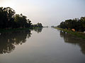 The Ganges Canal.
 The same East India Company bridge as in the lead paragraph photographed from the other side.
 A water mill on the canal.
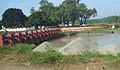 150-year-old locks on the canal.
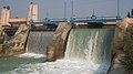 Small Hydroelectric Dam on Ganges Canal at Nagla Kabir UP
 Aquaduct of the Ganges Canal, Boorkee (5711515220)
 Hurdwar (Haridwar). India. May 1878
 Headworks ganges canal haridwar1860
 Photograph (2008) of an East India Company-era (1854) bridge on the Ganges Canal near Roorkee
 Photograph (2008) of the head works of the Ganges Canal in Haridwar, taken from the opposite side.
 The Ganges Canal (titel op object), RP-F-2001-7-1493


.jpg)


,_RP-F-2001-7-1493.jpg)

 Definitions from Wiktionary
 Media from Commons
 News from Wikinews
 Quotations from Wikiquote
 Texts from Wikisource
 Textbooks from Wikibooks
 Resources from Wikiversity