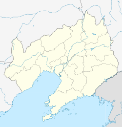
Dashiqiao
Appearance
Dashiqiao
大石桥市 Tashihkiao | |
|---|---|
 Location of the county within Yingkou | |
| Coordinates: 40°37′N 122°31′E / 40.617°N 122.517°E | |
| Country | People's Republic of China |
| Province | Liaoning |
| Prefecture-level city | Yingkou |
| Area | |
| 1,610.0 km2 (621.6 sq mi) | |
| • Urban | 150.00 km2 (57.92 sq mi) |
| Elevation | 45 m (148 ft) |
| Population (2020 census[2]) | |
| 607,098 | |
| • Density | 380/km2 (980/sq mi) |
| • Urban | 309,066 |
| Time zone | UTC+8 (China Standard) |
| Dashiqiao | |||||||||
|---|---|---|---|---|---|---|---|---|---|
| Simplified Chinese | 大石桥 | ||||||||
| Traditional Chinese | 大石橋 | ||||||||
| Postal | Tashihkiao | ||||||||
| |||||||||
Dashiqiao (simplified Chinese: 大石桥; traditional Chinese: 大石橋; pinyin: Dàshíqiáo; lit. 'Great Stone Bridge') is a county-level city in south-central Liaoning province, Northeast China. It is under the administration of the prefectural city of Yingkou, the downtown of which is 23 kilometres (14 mi) to the west.
Administrative Divisions
[edit]There are five subdistricts and 11 towns under the city's administration.[3]
Subdistricts:
- Shiqiao Subdistrict (石桥街道), Qinghua Subdistrict (青花街道), Jinqiao Subdistrict (金桥街道), Gangdu Subdistrict (钢都街道), Nanlou Subdistrict (南楼街道)
Towns:
- Shuiyuan (水源镇), Gouyan (沟沿镇), Shifo (石佛镇), Gaokan (高坎镇), Qikou, Huzhuang (虎庄镇), Guantun (官屯镇), Boluopu (博洛铺镇), Yong'an (永安镇), Tangchi (汤池镇), Huangtuling (黄土岭镇), Zhoujia (周家镇)
Climate
[edit]| Climate data for Dashiqiao (1991–2014 normals, extremes 1981–2010) | |||||||||||||
|---|---|---|---|---|---|---|---|---|---|---|---|---|---|
| Month | Jan | Feb | Mar | Apr | May | Jun | Jul | Aug | Sep | Oct | Nov | Dec | Year |
| Record high °C (°F) | 9.1 (48.4) |
19.1 (66.4) |
21.1 (70.0) |
29.9 (85.8) |
34.1 (93.4) |
34.5 (94.1) |
35.0 (95.0) |
35.3 (95.5) |
33.1 (91.6) |
28.1 (82.6) |
21.0 (69.8) |
14.6 (58.3) |
35.3 (95.5) |
| Mean daily maximum °C (°F) | −2.8 (27.0) |
1.7 (35.1) |
8.1 (46.6) |
17.1 (62.8) |
23.8 (74.8) |
27.5 (81.5) |
29.6 (85.3) |
29.2 (84.6) |
25.2 (77.4) |
17.5 (63.5) |
7.7 (45.9) |
−0.3 (31.5) |
15.4 (59.7) |
| Daily mean °C (°F) | −8.2 (17.2) |
−3.8 (25.2) |
2.8 (37.0) |
11.5 (52.7) |
18.4 (65.1) |
22.8 (73.0) |
25.5 (77.9) |
24.7 (76.5) |
19.5 (67.1) |
11.9 (53.4) |
2.6 (36.7) |
−5.3 (22.5) |
10.2 (50.4) |
| Mean daily minimum °C (°F) | −12.9 (8.8) |
−8.6 (16.5) |
−1.9 (28.6) |
6.1 (43.0) |
13.2 (55.8) |
18.4 (65.1) |
22.0 (71.6) |
20.9 (69.6) |
14.5 (58.1) |
6.9 (44.4) |
−1.8 (28.8) |
−9.6 (14.7) |
5.6 (42.1) |
| Record low °C (°F) | −30.8 (−23.4) |
−27.2 (−17.0) |
−18.1 (−0.6) |
−6.9 (19.6) |
0.3 (32.5) |
7.2 (45.0) |
13.8 (56.8) |
11.8 (53.2) |
0.3 (32.5) |
−7.2 (19.0) |
−17.8 (0.0) |
−23.2 (−9.8) |
−30.8 (−23.4) |
| Average precipitation mm (inches) | 3.7 (0.15) |
7.0 (0.28) |
11.7 (0.46) |
32.7 (1.29) |
53.5 (2.11) |
77.3 (3.04) |
141.9 (5.59) |
165.2 (6.50) |
53.6 (2.11) |
36.5 (1.44) |
20.8 (0.82) |
8.7 (0.34) |
612.6 (24.13) |
| Average precipitation days (≥ 0.1 mm) | 2.6 | 2.7 | 3.9 | 6.1 | 7.8 | 9.6 | 10.6 | 10.1 | 6.8 | 6.2 | 5.1 | 3.3 | 74.8 |
| Average snowy days | 4.0 | 3.4 | 2.8 | 0.7 | 0 | 0 | 0 | 0 | 0 | 0.3 | 3.2 | 4.0 | 18.4 |
| Average relative humidity (%) | 58 | 53 | 52 | 51 | 55 | 67 | 77 | 78 | 70 | 63 | 61 | 60 | 62 |
| Mean monthly sunshine hours | 186.8 | 192.6 | 232.8 | 240.3 | 264.9 | 228.4 | 199.1 | 206.5 | 227.5 | 212.5 | 168.8 | 167.0 | 2,527.2 |
| Percent possible sunshine | 63 | 64 | 63 | 60 | 59 | 51 | 44 | 49 | 62 | 62 | 57 | 58 | 58 |
| Source: China Meteorological Administration[4][5] | |||||||||||||
References
[edit]- ^ Ministry of Housing and Urban-Rural Development, ed. (2019). China Urban Construction Statistical Yearbook 2017. Beijing: China Statistics Press. p. 50. Archived from the original on 18 June 2019. Retrieved 11 January 2020.
- ^ "China: Liáoníng (Prefectures, Cities, Districts and Counties) – Population Statistics, Charts and Map".
- ^ 营口市-行政区划网
- ^ 中国气象数据网 – WeatherBk Data (in Simplified Chinese). China Meteorological Administration. Retrieved 29 July 2023.
- ^ 中国气象数据网 (in Simplified Chinese). China Meteorological Administration. Retrieved 29 July 2023.
External links
[edit]

