NASA has released a global digital map of Saturn’s largest moon, Titan, and two polar stereographic maps its northern and southern hemispheres.

This global digital map of Titan was created using images taken by Cassini’s imaging science subsystem (ISS). The mean radius of Titan used for projection of this map is 1,600 miles (2,575 km). Titan is assumed to be spherical until a control network is created at some point in the future. Image credit: NASA / JPL-Caltech / Space Science Institute.
The global map of Titan was created using images taken by NASA’s Cassini spacecraft on April 7, 2014.
The images were taken using a filter centered at 938 nanometers, allowing NASA planetary scientists to examine variations in albedo across the surface of the moon. Because of the scattering of light by Titan’s dense atmosphere, no topographic shading is visible in these images.
The map is an update to the previous versions released in April 2011 and February 2009.
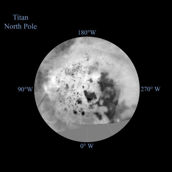
Mapping coverage in the northern polar region has greatly improved since 2011. Large dark areas, now known to be liquid-hydrocarbon-filled lakes and seas, have since been documented at high latitudes.
Titan’s north pole was not well illuminated early in Cassini’s mission, because it was winter in the northern hemisphere when the spacecraft arrived at Saturn.
The spacecraft has been better able to observe northern latitudes in more recent years due to seasonal changes in solar illumination.
A data gap of 3 – 5% of Titan’s surface still remains, located in the northern mid-latitudes on the sub-Saturn hemisphere of the moon.
The uniform gray area in the northern hemisphere indicates a gap in the imaging coverage of Titan’s surface, to date.
The missing data will be imaged by Cassini during flybys on December 15, 2016 and March 5, 2017.

The northern hemisphere of Titan is seen in this polar stereographic map, assembled in 2015 using the images of the moon from NASA’s Cassini mission. The mean radius of Titan used for projection of this map is 1,600 miles (2,575 km). Image credit: NASA / JPL-Caltech / Space Science Institute.

The southern hemisphere of Titan is seen in this polar stereographic map, assembled in 2015 using the images of the moon from NASA’s Cassini mission. The mean radius of Titan used for projection of this map is 1,600 miles (2,575 km). Image credit: NASA / JPL-Caltech / Space Science Institute.
The northern and southern hemispheres of Titan are seen in the two newly-released polar stereographic maps.
Lakes are seen in the southern hemisphere map, but they are much less common than in the north polar region.
The dark, footprint-shaped feature at 180 degrees west is Ontario Lacus.
A smaller lake named Crveno Lacus can be seen as a very dark spot just above Ontario.
The dark-albedo area seen at the top of the southern hemisphere map (at 0 degrees west) is an area called Mezzoramia.
Each map is centered on one of the poles, and surface coverage extends southward to 60 degrees latitude. Grid lines indicate latitude in 10-degree increments and longitude in 30-degree increments.


