|
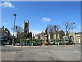
Sir John's Square, Thurso
by Malc McDonald
geograph for square ND1168
Sir John's Square in the centre of Thurso, on the north coast of Scotland.... (more)
|
|
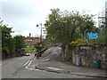
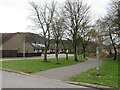
Culduthel Road and Gordon Terrace, Inverness
by Malc McDonald
geograph for square NH6644
Culduthel Road leads down the hill to Inverness Castle. The castle is visible... (more)
|
|
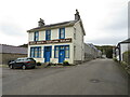
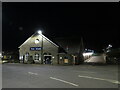
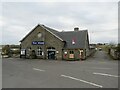
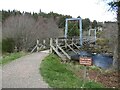
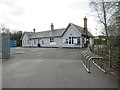
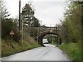
Former railway building, Braemar
by Malc McDonald
geograph for square NO1591
Despite the Great North of Scotland Railway sign on this building, it was never... (more)
|
|
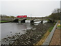
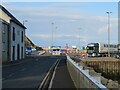
Thurso Bridge
by Malc McDonald
geograph for square ND1168
Thurso Bridge, in the town of Thurso, carries the A9 trunk road across the River... (more)
|
|
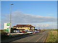
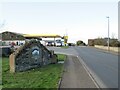
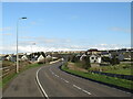
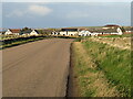
A836 approaching Thurso
by Malc McDonald
geograph for square ND1068
A view along the A836 road as it approaches Thurso. At the junction ahead it... (more)
|
|
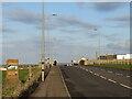
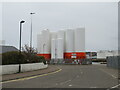
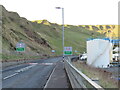
A9 entering Thurso
by Malc McDonald
geograph for square ND1068
A view of the A9 road entering the town of Thurso.
This section of road is on... (more)
|
|
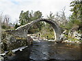
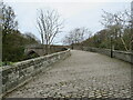
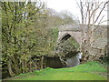
Old Pack Horse Bridge, Carrbridge, near Aviemore
by Malc McDonald
geograph for square NH9022
The Old Pack Horse Bridge over the River Dulnain at Carrbridge, in the... (more)
|
|
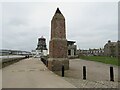
Scarty's Monument and Round House, Aberdeen Harbour
by Malc McDonald
geograph for square NJ9505
The brick tower in the foreground is known as Scarty's Monument, named... (more)
|
|
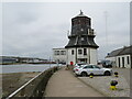
The Round House, Aberdeen Harbour
by Malc McDonald
geograph for square NJ9505
The Round House stands on the waterfront on Aberdeen's harbour. It used to... (more)
|
|
Pocra Quay, Footdee, Aberdeen
by Malc McDonald
geograph for square NJ9505
Pocra Quay stands at the mouth of the River Dee in Aberdeen.
|
|
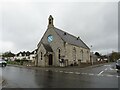
St. Andrew's Church, Aviemore
by Malc McDonald
geograph for square NH8912
St. Andrew's Church in the town of Aviemore, in the Highlands of Scotland.... (more)
|
|
Ormlie Road, Thurso
by Malc McDonald
geograph for square ND1067
Ormlie Road is on the route of the B874 road as it enters the town of Thurso on... (more)
|
|
Thurso station at night
by Malc McDonald
geograph for square ND1167
A night-time view of Thurso railway station. The station, on the Far North... (more)
|
|
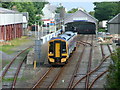
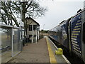
Thurso railway station
by Malc McDonald
geograph for square ND1167
The station building at Thurso, one of the termini of the Far North Line.
A... (more)
|
|
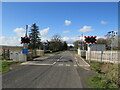
Level crossing at Halkirk
by Malc McDonald
geograph for square ND1358
A level crossing taking a minor road across the Far North Line at Halkirk, in... (more)
|
|
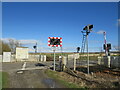
Level crossing at Halkirk
by Malc McDonald
geograph for square ND1358
A level crossing taking a minor road across the Far North Line at Halkirk, in... (more)
|
|
A9 road near Thurso
by Malc McDonald
geograph for square ND1069
A view of the trunk A9 road on the outskirts of Thurso on Scotland's north coast.
|
|
A9 entering Scrabster, near Thurso
by Malc McDonald
geograph for square ND0970
A view of the A9 road as it enters Scrabster, on the north coast of Scotland.... (more)
|
|
The end of the A9, Scrabster
by Malc McDonald
geograph for square ND1070
The A9 trunk road ends at the mini-roundabout ahead, in Scrabster on the north... (more)
|
|
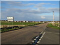
Road junction near Thurso
by Malc McDonald
geograph for square ND0968
A junction on the A836 road just outside Thurso, on the north coast of Scotland.... (more)
|
|
A836 approaching Thurso
by Malc McDonald
geograph for square ND0968
A view eastwards along the A836 road as it approaches Thurso, on Scotland's... (more)
|

|
The Kylesku Bridge, Great Britain
by Andrew Tryon
for square NC2233
The post-tensioned Kylesku bridge, which carries the A894, part of the North... (more)
|

|
The Great Polish Map of Scotland
by M J Richardson
geograph for square NT2347
Looking southwest along the 'Great Glen' - Glen Albyn or Glen Mor -... (more)
|

|
The Great Polish Map of Scotland
by M J Richardson
for square NT2347
Sutherland and the northern Munros.
|

|
The Great Polish Map of Scotland
by M J Richardson
geograph for square NT2347
Duncansby Head, Caithness and the Pentland Firth.
|

|
The Great Polish Map of Scotland
by M J Richardson
geograph for square NT2347
Sutherland and Cape Wrath.
|

|
The Great Polish Map of Scotland
by M J Richardson
geograph for square NT2347
Lochaber and Ben Nevis. Ben Nevis is marked by the white stick.
|

|
The Great Polish Map of Scotland
by M J Richardson
geograph for square NT2347
The Outer Hebrides -the Uists, Benbecula, Lewis and Harris.
|

|
The Great Polish Map of Scotland
by M J Richardson
geograph for square NT2347
A slightly crumbly Mull. The white stick in the centre is on Ben Nevis.
|

|
The Great Polish Map of Scotland
by M J Richardson
geograph for square NT2347
The Firth of Clyde, Arran and the Mull of Kintyre.
|

|
The Great Polish Map of Scotland
by M J Richardson
geograph for square NT2347
Carrick, Arran and the Mull of Kintyre.
|

|
The Great Polish Map of Scotland
by M J Richardson
geograph for square NT2347
Wigtown and the Mull of Galloway.
|

|
The Great Polish Map of Scotland
by M J Richardson
geograph for square NT2347
The Scottish Borders, Lothians and Fife.
|

|
The National Gallery of Scotland
by Steven Haslington
geograph for square NT2573
Category: Art gallery
The National Gallery of Scotland in central Edinburgh. It's built in a... (more)
|
|
Thurso station
by Malc McDonald
geograph for square ND1167
Category: Railway station
Thurso station is the most northerly point on the British railway network.
In... (more)
|
|
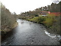
River Dulnain at Carrbridge, near Aviemore
by Malc McDonald
geograph for square NH8922
A view of the River Dulnain at Carrbridge, in the Cairngorms National Park.
|
|
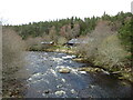
River Dulnain at Carrbridge, near Aviemore
by Malc McDonald
geograph for square NH8922
A view of the River Dulnain at Carrbridge, in the Cairngorms National Park.
|
|
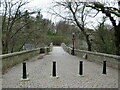
Ellan Bridge, Carrbridge, near Aviemore
by Malc McDonald
geograph for square NH8922
Ellan Bridge is a footbridge over the River Dulnain at Carrbridge, in the... (more)
|
|
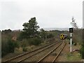
Highland Main Line at Carrbridge, near Aviemore
by Malc McDonald
geograph for square NH8922
A train formed of diesel multiple units leaves Carrbridge station on the... (more)
|
|
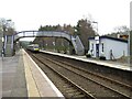
Carrbridge railway station
by Malc McDonald
geograph for square NH8922
A Class 170 "Turbostar" diesel multiple unit arriving at Carrbridge... (more)
|
|
Carrbridge railway station
by Malc McDonald
geograph for square NH8922
Carrbridge station on the Highland Main Line. Carrbridge is within the... (more)
|
|
Bridge over Station Road, Carrbridge, near Aviemore
by Malc McDonald
geograph for square NH8922
A bridge carries the Highland Main Line over Station Road in the village of... (more)
|
|
Deeside Way, Ballater
by Malc McDonald
geograph for square NO3796
Deeside Way leaving the town of Ballater in Royal Deeside. Ballater lies within... (more)
|
|
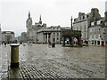
Castlegate, Aberdeen
by Malc McDonald
geograph for square NJ9406
Castlegate is a pedestriansed square in the centre of Aberdeen. The city's... (more)
|
|
Brig o' Balgownie, Old Aberdeen
by Malc McDonald
geograph for square NJ9409
A view onto the Brig o' Balgownie from the south side.
|
|
Brig o' Balgownie, Old Aberdeen
by Malc McDonald
geograph for square NJ9409
|
|
Brig o' Balgownie, Old Aberdeen
by Malc McDonald
geograph for square NJ9409
A view onto the Brig o' Balgownie from the north.
|
|
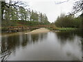
River Spey near Aviemore
by Malc McDonald
geograph for square NH9012
A view of the River Spey near Aviemore, in the Highlands of Scotland. This area... (more)
|
|
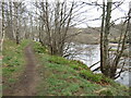
Path along the River Spey near Aviemore
by Malc McDonald
geograph for square NH9012
A path alongside the River Spey near Aviemore, in the Highlands of Scotland.... (more)
|
|
Forsinard station, Sutherland
by Malc McDonald
geograph for square NC8942
Forsinard is a remote station in the county of Sutherland, on Scotland's... (more)
|