เกาะบราช
หน้าตา
 | |
 ที่ตั้งของเกาะบราช | |
| ภูมิศาสตร์ | |
|---|---|
| ที่ตั้ง | ทะเลเอเดรียติก |
| พิกัด | 43°19′N 16°38′E / 43.317°N 16.633°E |
| กลุ่มเกาะ | Dalmatian Archipielago |
| พื้นที่ | 396 ตารางกิโลเมตร (153 ตารางไมล์) |
| ระดับสูงสุด | 780 ม. (2560 ฟุต) |
| จุดสูงสุด | Vidova gora |
| การปกครอง | |
โครเอเชีย | |
| เทศมณฑล | Split-Dalmatia |
| เมืองใหญ่สุด | Supetar (ประชากร 3,326 คน) |
| ประชากรศาสตร์ | |
| ประชากร | 13,931 (2021) |
| ความหนาแน่น | 35/กม.2 (91/ตารางไมล์) |
| กลุ่มชาติพันธุ์ | ชาวโครแอต |
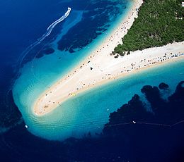
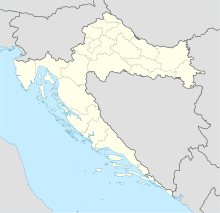
บราช (โครเอเชีย: Brač, ออกเสียง: [brâːtʃ]; ภาษาถิ่น: Broč) เป็นเกาะในทะเลเอเดรียติก นอกชายฝั่งแดลเมเชีย ของประเทศโครเอเชีย มีพื้นที่ 396 ตารางกิโลเมตร[1] ทำให้เป็นเกาะใหญ่ที่สุดในแดลเมเชีย และเป็นเกาะใหญ่เป็นอันดับ 3 ในทะเลเอเดรียติก เกาะมีประชากร 14,436 คน[2]
อ้างอิง
[แก้]- ↑ Duplančić Leder, Tea; Ujević, Tin; Čala, Mendi (June 2004). "Coastline lengths and areas of islands in the Croatian part of the Adriatic Sea determined from the topographic maps at the scale of 1 : 25 000" (PDF). Geoadria. Zadar. 9 (1): 5–32. doi:10.15291/geoadria.127. สืบค้นเมื่อ 2019-11-25.
- ↑ 2011 census, https://www.dzs.hr/Hrv_Eng/publication/2011/SI-1441.pdf เก็บถาวร 2014-08-19 ที่ เวย์แบ็กแมชชีน
ผลงานที่อ้างถึง
[แก้]- Cartledge, Bryan (2011). The Will to Survive: A History of Hungary. C. Hurst & Co. ISBN 978-1-84904-112-6.
- Curta, Florin (2006). Southeastern Europe in the Middle Ages, 500–1250. Cambridge University Press. ISBN 978-0-521-89452-4.
- Engel, Pál (2001). The Realm of St Stephen: A History of Medieval Hungary, 895–1526. I.B. Tauris Publishers. ISBN 1-86064-061-3.
- Érszegi, Géza; Solymosi, László (1981). "Az Árpádok királysága, 1000–1301 [The Monarchy of the Árpáds, 1000–1301]". ใน Solymosi, László (บ.ก.). Magyarország történeti kronológiája, I: a kezdetektől 1526-ig [Historical Chronology of Hungary, Volume I: From the Beginning to 1526] (ภาษาฮังการี). Akadémiai Kiadó. pp. 79–187. ISBN 963-05-2661-1.
- Fine, John V. A. Jr. (1991) [1983]. The Early Medieval Balkans: A Critical Survey from the Sixth to the Late Twelfth Century. Ann Arbor: University of Michigan Press. ISBN 0-472-08149-7.
- Fine, John V. A. Jr. (1994) [1987]. The Late Medieval Balkans: A Critical Survey from the Late Twelfth Century to the Ottoman Conquest. Ann Arbor, Michigan: University of Michigan Press. ISBN 0-472-08260-4.
- Font, Márta (2001). Koloman the Learned, King of Hungary (Supervised by Gyula Kristó, Translated by Monika Miklán). Márta Font (supported by the Publication Commission of the Faculty of Humanities of the University of Pécs). ISBN 963-482-521-4.
- Grousset, René (1970). The Empire of the Steppes. Rutgers. ISBN 0-8135-1304-9.
- Kristó, Gyula; Makk, Ferenc (1996). Az Árpád-ház uralkodói [Rulers of the House of Árpád] (ภาษาฮังการี). I.P.C. Könyvek. ISBN 978-963-7930-97-3.
- Majnarić, Ivan (2005), "Kačići", Croatian Biographical Lexicon (HBL) (ภาษาโครเอเชีย), Miroslav Krleža Lexicographical Institute, สืบค้นเมื่อ 11 September 2012
- Makk, Ferenc (1989). The Árpáds and the Comneni: Political Relations between Hungary and Byzantium in the 12th century (Translated by György Novák). Akadémiai Kiadó. ISBN 963-05-5268-X.
- Solymosi, László; Körmendi, Adrienne (1981). "A középkori magyar állam virágzása és bukása, 1301–1506 [The Heyday and Fall of the Medieval Hungarian State, 1301–1526]". ใน Solymosi, László (บ.ก.). Magyarország történeti kronológiája, I: a kezdetektől 1526-ig [Historical Chronology of Hungary, Volume I: From the Beginning to 1526] (ภาษาฮังการี). Akadémiai Kiadó. pp. 188–228. ISBN 963-05-2661-1.
- Stephenson, Paul (2000). Byzantium's Balkan Frontier: A Political Study of the Northern Balkans, 900–1204. Cambridge University Press. ISBN 978-0-521-02756-4.
- Tanner, Marcus (2010). Croatia: A Nation Forged in War. Yale University Press. ISBN 978-0-300-16394-0.

