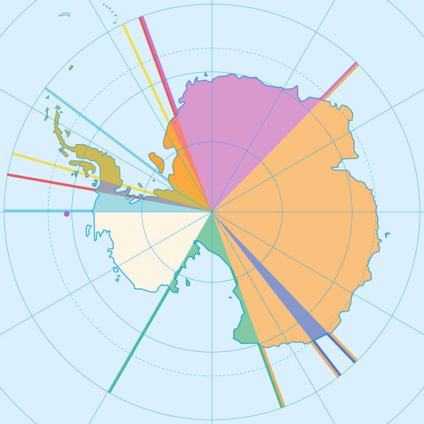
File:Antarctica, territorial claims.svg
Aspetto

Dimensioni di questa anteprima PNG per questo file SVG: 600 × 600 pixel. Altre risoluzioni: 240 × 240 pixel | 480 × 480 pixel | 768 × 768 pixel | 1 024 × 1 024 pixel | 2 048 × 2 048 pixel | 820 × 820 pixel.
File originale (file in formato SVG, dimensioni nominali 820 × 820 pixel, dimensione del file: 72 KB)
Cronologia del file
Fare clic su un gruppo data/ora per vedere il file come si presentava nel momento indicato.
| Data/Ora | Miniatura | Dimensioni | Utente | Commento | |
|---|---|---|---|---|---|
| attuale | 17:42, 8 mag 2020 |  | 820 × 820 (72 KB) | Spesh531 | Norway's claim stretches to the South Pole as of June 12 2015 |
| 05:31, 13 ott 2009 |  | 820 × 820 (71 KB) | DooFi | sauerkraut | |
| 21:08, 30 giu 2008 |  | 806 × 806 (43 KB) | Lokal Profil | {{Information |Description={{en|Map showing the territorial claims to Antarctica}} {{legend|#e987eb|New Zealand}} {{legend|#fcc475|Australia}} {{legend|#8282ed|France}} {{legend|#7efa72|Norway}} {{legend|#ec787f|United Kingdom}} {{legend|#6db87f|Chile}} { |
Pagine che usano questo file
Le seguenti 41 pagine usano questo file:
- Antartide
- Antartide Brasiliana
- Antartide argentina
- Costa del Principe Harald
- Costa del Principe Olav
- Costa della Principessa Astrid
- Costa della Principessa Marta
- Costa della Principessa Ragnhild
- Costa di Caird
- Costa di Luitpold
- Costa di Zumberge
- Dipendenza di Ross
- Dipendenze della Norvegia
- Georgia del Sud e Isole Sandwich Australi
- Isola Bouvet
- Isola Pietro I
- Isole Heard e McDonald
- Nuova Svevia
- Rivendicazioni territoriali in Antartide
- Terra Adelia
- Terra della Principessa Elisabetta
- Terra della Regina Maria
- Terra della Regina Maud
- Terra di Edith Ronne
- Terra di Enderby
- Terra di Giorgio V
- Terra di Graham
- Terra di Guglielmo II
- Terra di Kemp
- Terra di Mac. Robertson
- Terra di Marie Byrd
- Terra di Oates
- Terra di Palmer
- Terra di Wilkes
- Terre Australi e Antartiche Francesi
- Territorio Antartico Australiano
- Territorio Antartico Britannico
- Territorio antartico cileno
- Trattato Antartico
- Yamato Yukihara
- Template:Rivendicazioni Antartide
Utilizzo globale del file
Anche i seguenti wiki usano questo file:
- Usato nelle seguenti pagine di af.wikipedia.org:
- Usato nelle seguenti pagine di ar.wikipedia.org:
- Usato nelle seguenti pagine di ast.wikipedia.org:
- Usato nelle seguenti pagine di az.wikipedia.org:
- Usato nelle seguenti pagine di bn.wikipedia.org:
- Usato nelle seguenti pagine di cs.wikipedia.org:
- Usato nelle seguenti pagine di de.wikipedia.org:
- Usato nelle seguenti pagine di en.wikipedia.org:
- Usato nelle seguenti pagine di es.wikipedia.org:
- Usato nelle seguenti pagine di eu.wikipedia.org:
- Usato nelle seguenti pagine di fa.wikipedia.org:
- Usato nelle seguenti pagine di frr.wikipedia.org:
- Usato nelle seguenti pagine di fy.wikipedia.org:
- Usato nelle seguenti pagine di gl.wikipedia.org:
- Usato nelle seguenti pagine di hu.wikipedia.org:
- Usato nelle seguenti pagine di hy.wikipedia.org:
- Usato nelle seguenti pagine di id.wikipedia.org:
Visualizza l'utilizzo globale di questo file.


