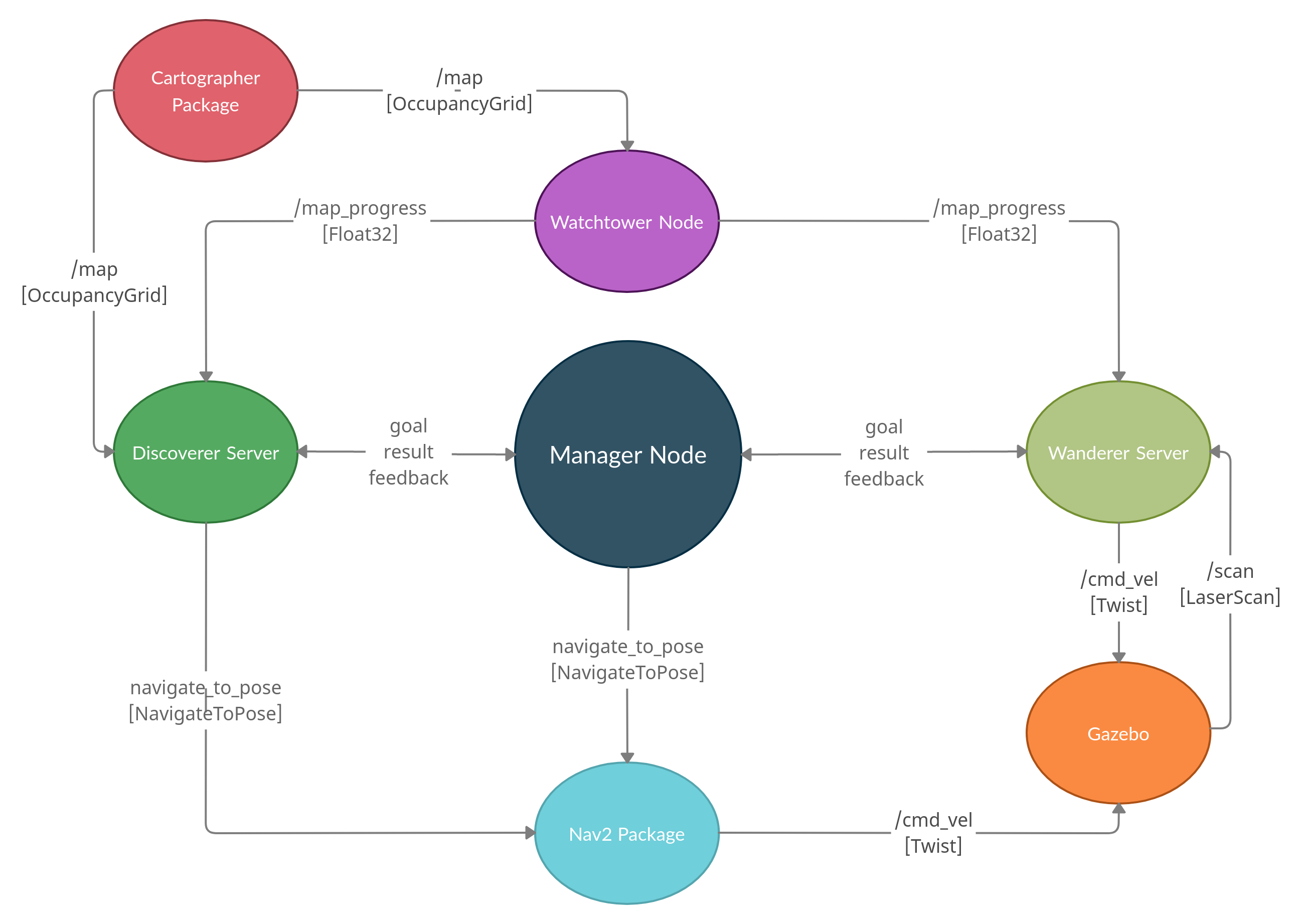
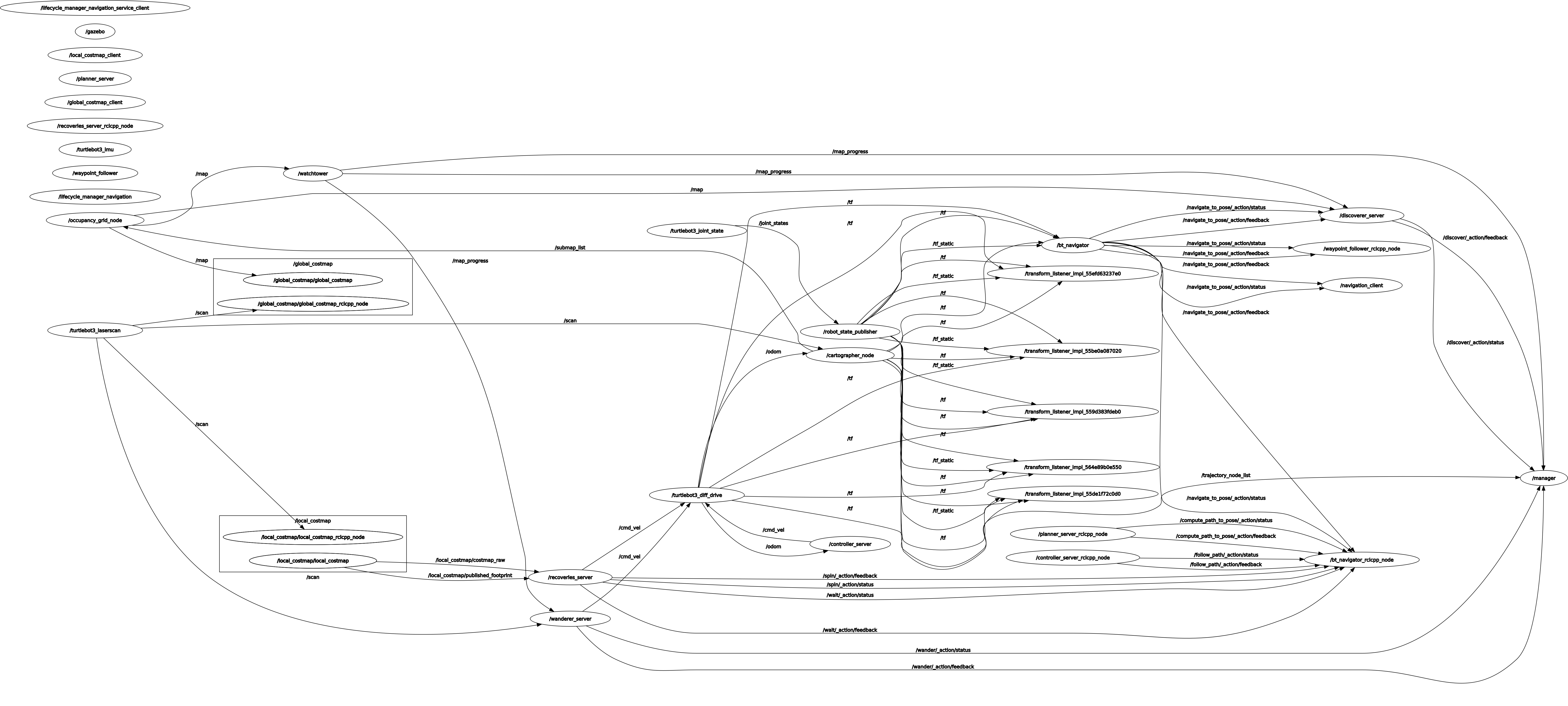
In this repo we use Turtlebot 3 along with ROS 2 and Gazebo to explore an unknown csv environment, navigate through it and create a map.
The map is created using SLAM with the package Google Cartographer and navigation is achieved with Nav2 package. We have developed two exploring algorithyms:
Wanderer Exploration explores the map doing random turns when it detects an obstacle. It's a convenient way to explore small maps but time consuming for bigger ones.
Discoverer Exploration prioritizes specific unknown hotspots of the map convoluting the occupancy grid. It's a better way to explore bigger maps in exchange of a higher computational cost.
Don't forget to install colcon:
sudo apt install python3-colcon-common-extensions
Install Gazebo:
curl -sSL https://get.gazebosim.org | sh
Install packages:
sudo apt install ros-humble-gazebo-ros-pkgs ros-humble-cartographer ros-humble-cartographer-ros ros-humble-navigation2 ros-humble-nav2-bringup
sudo apt install ros-humble-turtlebot3-msgs ros-humble-dynamixel-sdk ros-humble-hls-lfcd-lds-driver
Install Python libraries:
sudo apt install python3-pip
pip3 install pandas
Create a ROS2 workspace:
mkdir -p ~/ros2_ws/src
cd ~/ros2_ws/src
Clone the repository:
git clone https://github.com/Qeneb/ros2_explorer.git
Clone turtlebot original repository to have additional utilities:
git clone -b humble-devel https://github.com/ROBOTIS-GIT/turtlebot3.git
git clone -b humble-devel https://github.com/ROBOTIS-GIT/turtlebot3_simulations.git
Include following lines in ~/.bashrc:
source /opt/ros/humble/setup.bash
source /usr/share/colcon_cd/function/colcon_cd.sh
export _colcon_cd_root=~/ros2_ws
source ~/ros2_ws/install/setup.bash

export TURTLEBOT3_MODEL=burger
export GAZEBO_MODEL_PATH=~/ros2_ws/src/ros2_explorer/explorer_gazebo/models
Compile packages:
cd ~/turtlebot3_ws/
colcon build
Execute the launch file of the map you want to use (Opens Gazebo simulation, Rviz, Cartographer, Nav2 and exploration servers):
ros2 launch explorer_bringup map1.launch.py
Execute manager node and select exploring algorithm:
ros2 run explorer_bringup manager
Add your own csv maps in this folder:
cd ~/turtlebot3_ws/src/ros2_explorer/explorer_gazebo/maps/
Run Python script:
cd ~/turtlebot3_ws/src/ros2_explorer/explorer_gazebo/
python3 gazebo-map-from-csv.py
Maps will be converted to Gazebo format in /explorer_gazebo/models folder. Create a new .world.xml file in /explorer_gazebo/worlds and modify the name of the map you want to use:
<include>
  <uri>model:https://map1</uri>
</include>
Create a new launch file in /explorer_bringup/launch folder and modify the parameter map_name according to the map you just created.
Cartographer launch:
ros2 launch explorer_cartographer cartographer.launch.py use_sim_time:=True
Navigation launch:
ros2 launch explorer_navigation2 nav.launch.py use_sim_time:=True
Move the robot manually:
ros2 run turtlebot3_teleop teleop_keyboard
Save a map:
ros2 run nav2_map_server map_saver_cli
Publish a goal:
ros2 action send_goal /navigate_to_pose nav2_msgs/action/NavigateToPose "{pose: {header: {stamp: {sec: 0}, frame_id: 'map'}, pose: {position: {x: 0.0, y: 0.0, z: 0.0}, orientation: {w: 1.0}}}}"


